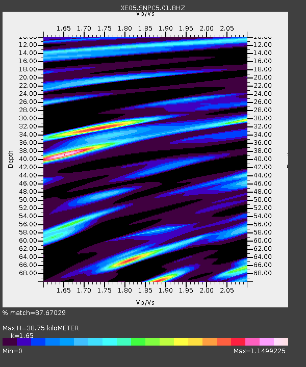
SNPC5 SNPC5 - Earthquake Result Viewer

Earthquake location: Mariana Islands
Earthquake latitude/longitude: 21.0/144.7
Earthquake time(UTC): 2007/01/30 (030) 21:37:45 GMT
Earthquake Depth: 30 km
Earthquake Magnitude: 6.3 MB, 6.5 MS, 6.6 MW, 6.5 MW
Earthquake Catalog/Contributor: WHDF/NEIC
Network: XE Sierra Nevada EarthScope Project- EarthScope Flex Array
Station: SNPC5 SNPC5
Lat/Lon: 39.03 N/120.75 W
Elevation: 1006 m
Distance: 80.5 deg
Az: 51.935 deg
Baz: 289.168 deg
Ray Param: 0.04821483
Estimated Moho Depth: 38.75 km
Estimated Crust Vp/Vs: 1.65
Assumed Crust Vp: 6.597 km/s
Estimated Crust Vs: 3.998 km/s
Estimated Crust Poisson's Ratio: 0.21
Radial Match: 87.67029 %
Radial Bump: 400
Transverse Match: 68.76708 %
Transverse Bump: 400
SOD ConfigId: 268666
Insert Time: 2010-03-09 18:22:12.755 +0000
GWidth: 2.5
Max Bumps: 400
Tol: 0.001

Signal To Noise

ChannelStoNSTALTA
XE:SNPC5:01:BHZ:20070130T21:49:23.613997Z17.4245471.7679217E-61.0146156E-7
XE:SNPC5:01:BHN:20070130T21:49:23.613997Z1.63423386.5626233E-74.015719E-7
XE:SNPC5:01:BHE:20070130T21:49:23.613997Z4.9465887.3094697E-71.477679E-7
Arrivals
Ps3.9 SECOND
PpPs15 SECOND
PsPs/PpSs19 SECOND