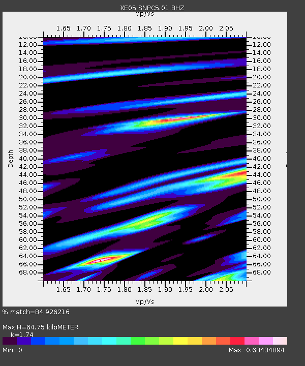
SNPC5 SNPC5 - Earthquake Result Viewer

Earthquake location: Loyalty Islands
Earthquake latitude/longitude: -20.7/168.8
Earthquake time(UTC): 2007/04/04 (094) 11:00:27 GMT
Earthquake Depth: 10 km
Earthquake Magnitude: 5.8 MB, 6.4 MS, 6.2 MW, 6.1 MW
Earthquake Catalog/Contributor: WHDF/NEIC
Network: XE Sierra Nevada EarthScope Project- EarthScope Flex Array
Station: SNPC5 SNPC5
Lat/Lon: 39.03 N/120.75 W
Elevation: 1006 m
Distance: 88.6 deg
Az: 47.228 deg
Baz: 241.917 deg
Ray Param: 0.042442776
Estimated Moho Depth: 64.75 km
Estimated Crust Vp/Vs: 1.74
Assumed Crust Vp: 6.597 km/s
Estimated Crust Vs: 3.792 km/s
Estimated Crust Poisson's Ratio: 0.25
Radial Match: 84.926216 %
Radial Bump: 400
Transverse Match: 61.666855 %
Transverse Bump: 400
SOD ConfigId: 268666
Insert Time: 2010-03-09 18:22:15.727 +0000
GWidth: 2.5
Max Bumps: 400
Tol: 0.001

Signal To Noise

ChannelStoNSTALTA
XE:SNPC5:01:BHZ:20070404T11:12:49.065Z6.936876.77107E-79.760987E-8
XE:SNPC5:01:BHN:20070404T11:12:49.065Z2.07867462.1722443E-71.0450142E-7
XE:SNPC5:01:BHE:20070404T11:12:49.065Z2.26649672.8655623E-71.2643135E-7
Arrivals
Ps7.4 SECOND
PpPs26 SECOND
PsPs/PpSs34 SECOND