You are here: Home > Network List > IW - Intermountain West Stations List
> Station MOOW Moose Ponds, Wyoming, USA > Earthquake Result Viewer
MOOW Moose Ponds, Wyoming, USA - Earthquake Result Viewer
*The percent match for this event was below the threshold and hence no stack was calculated.
| Earthquake location: |
Near East Coast Of Honshu, Japan |
| Earthquake latitude/longitude: |
37.4/141.7 |
| Earthquake time(UTC): |
2022/04/04 (094) 10:29:04 GMT |
| Earthquake Depth: |
37 km |
| Earthquake Magnitude: |
5.5 mww |
| Earthquake Catalog/Contributor: |
NEIC PDE/us |
|
| Network: |
IW Intermountain West |
| Station: |
MOOW Moose Ponds, Wyoming, USA |
| Lat/Lon: |
43.75 N/110.74 W |
| Elevation: |
2128 m |
|
| Distance: |
76.0 deg |
| Az: |
45.405 deg |
| Baz: |
308.495 deg |
| Ray Param: |
$rayparam |
*The percent match for this event was below the threshold and hence was not used in the summary stack. |
|
| Radial Match: |
49.208817 % |
| Radial Bump: |
400 |
| Transverse Match: |
51.856636 % |
| Transverse Bump: |
400 |
| SOD ConfigId: |
27527651 |
| Insert Time: |
2022-04-18 10:43:31.206 +0000 |
| GWidth: |
2.5 |
| Max Bumps: |
400 |
| Tol: |
0.001 |
|
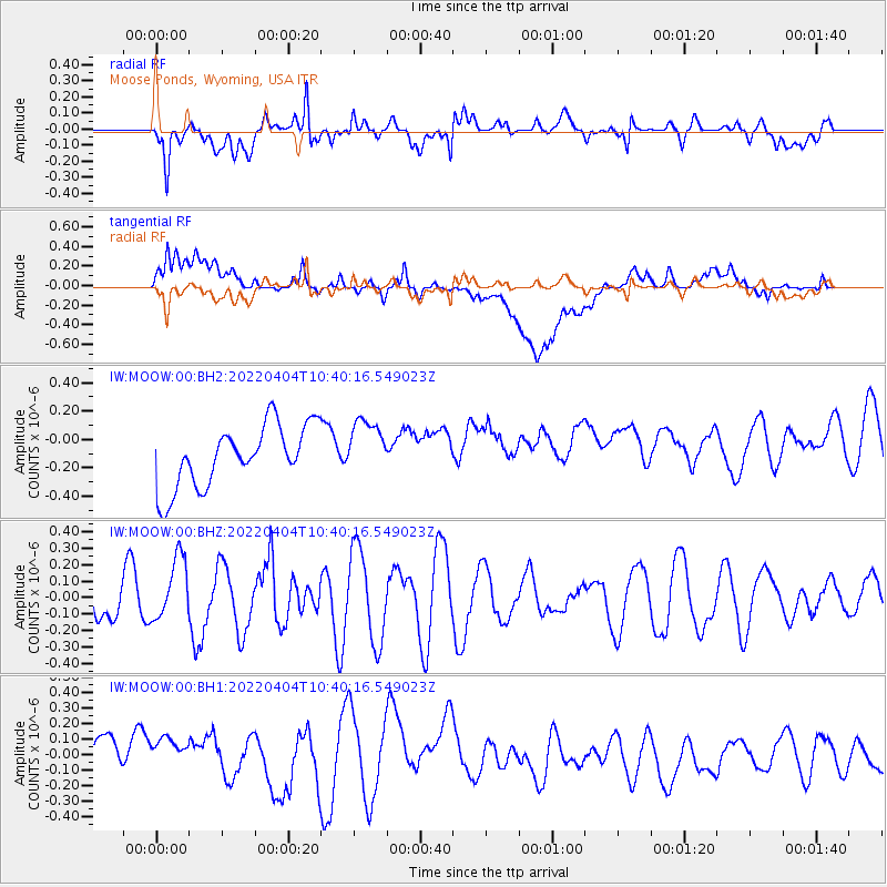
Signal To Noise
| Channel | StoN | STA | LTA |
| IW:MOOW:00:BHZ:20220404T10:40:16.549023Z | 1.8627822 | 1.9024502E-7 | 1.021295E-7 |
| IW:MOOW:00:BH1:20220404T10:40:16.549023Z | 1.0848676 | 2.3376607E-7 | 2.1547888E-7 |
| IW:MOOW:00:BH2:20220404T10:40:16.549023Z | 0.9447874 | 2.0369075E-7 | 2.1559427E-7 |
| Arrivals |
| Ps | |
| PpPs | |
| PsPs/PpSs | |


