You are here: Home > Network List > TA - USArray Transportable Network (new EarthScope stations) Stations List
> Station TOLK Toolik Lake Research Station, AK, USA > Earthquake Result Viewer
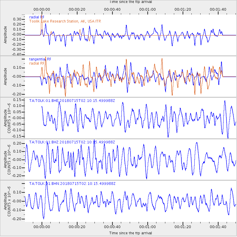
TOLK Toolik Lake Research Station, AK, USA - Earthquake Result Viewer
*The percent match for this event was below the threshold and hence no stack was calculated.
| Earthquake location: |
Eastern Gulf Of Aden |
| Earthquake latitude/longitude: |
14.1/51.7 |
| Earthquake time(UTC): |
2018/07/15 (196) 01:57:19 GMT |
| Earthquake Depth: |
10 km |
| Earthquake Magnitude: |
6.0 Mww |
| Earthquake Catalog/Contributor: |
NEIC PDE/us |
|
| Network: |
TA USArray Transportable Network (new EarthScope stations) |
| Station: |
TOLK Toolik Lake Research Station, AK, USA |
| Lat/Lon: |
68.64 N/149.57 W |
| Elevation: |
760 m |
|
| Distance: |
96.1 deg |
| Az: |
7.69 deg |
| Baz: |
339.239 deg |
| Ray Param: |
$rayparam |
*The percent match for this event was below the threshold and hence was not used in the summary stack. |
|
| Radial Match: |
60.074924 % |
| Radial Bump: |
400 |
| Transverse Match: |
44.12373 % |
| Transverse Bump: |
400 |
| SOD ConfigId: |
2768671 |
| Insert Time: |
2018-07-29 02:04:37.761 +0000 |
| GWidth: |
2.5 |
| Max Bumps: |
400 |
| Tol: |
0.001 |
|
Signal To Noise
| Channel | StoN | STA | LTA |
| TA:TOLK:01:BHZ:20180715T02:10:15.499988Z | 1.7653308 | 1.2172957E-7 | 6.895567E-8 |
| TA:TOLK:01:BHN:20180715T02:10:15.499988Z | 1.7487354 | 1.2104726E-7 | 6.921988E-8 |
| TA:TOLK:01:BHE:20180715T02:10:15.499988Z | 0.89620334 | 5.168423E-8 | 5.7670203E-8 |
| Arrivals |
| Ps | |
| PpPs | |
| PsPs/PpSs | |


