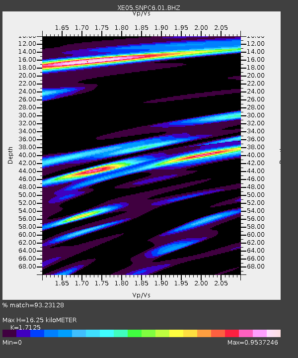
SNPC6 SNPC6 - Earthquake Result Viewer

Earthquake location: Kuril Islands
Earthquake latitude/longitude: 46.5/153.2
Earthquake time(UTC): 2006/10/01 (274) 09:06:02 GMT
Earthquake Depth: 19 km
Earthquake Magnitude: 6.1 MB, 6.4 MS, 6.6 MW, 6.5 MW
Earthquake Catalog/Contributor: WHDF/NEIC
Network: XE Sierra Nevada EarthScope Project- EarthScope Flex Array
Station: SNPC6 SNPC6
Lat/Lon: 39.09 N/120.47 W
Elevation: 1887 m
Distance: 60.8 deg
Az: 62.884 deg
Baz: 307.768 deg
Ray Param: 0.061304767
Estimated Moho Depth: 16.25 km
Estimated Crust Vp/Vs: 1.71
Assumed Crust Vp: 6.597 km/s
Estimated Crust Vs: 3.853 km/s
Estimated Crust Poisson's Ratio: 0.24
Radial Match: 93.23128 %
Radial Bump: 400
Transverse Match: 63.887085 %
Transverse Bump: 400
SOD ConfigId: 268666
Insert Time: 2010-03-09 18:26:46.629 +0000
GWidth: 2.5
Max Bumps: 400
Tol: 0.001

Signal To Noise

ChannelStoNSTALTA
XE:SNPC6:01:BHZ:20061001T09:15:41.663994Z4.52237469.0889154E-72.0097661E-7
XE:SNPC6:01:BHN:20061001T09:15:41.663994Z2.1037352.5810994E-71.2269129E-7
XE:SNPC6:01:BHE:20061001T09:15:41.663994Z1.3771042.853661E-72.072219E-7
Arrivals
Ps1.8 SECOND
PpPs6.4 SECOND
PsPs/PpSs8.2 SECOND