You are here: Home > Network List > XE05 - Sierra Nevada EarthScope Project- EarthScope Flex Array Stations List
> Station SNPC6 SNPC6 > Earthquake Result Viewer
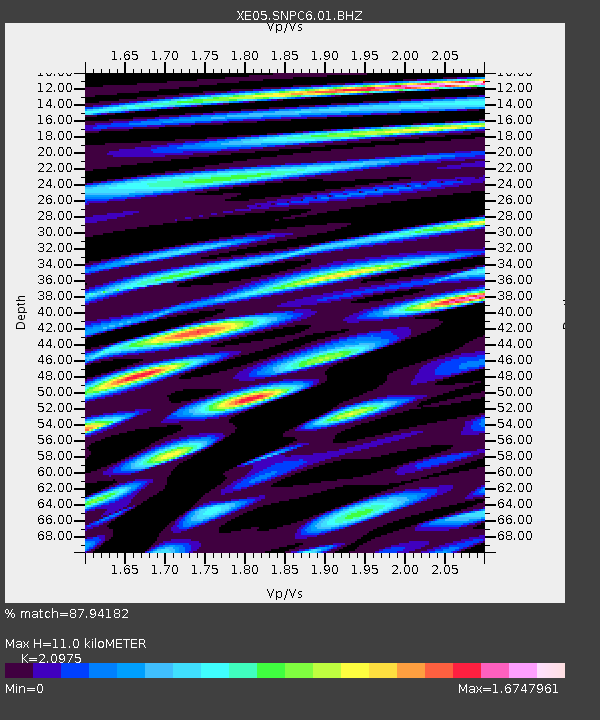
SNPC6 SNPC6 - Earthquake Result Viewer
| Earthquake location: |
Santiago Del Estero Prov., Arg. |
| Earthquake latitude/longitude: |
-26.0/-63.2 |
| Earthquake time(UTC): |
2006/11/13 (317) 01:26:34 GMT |
| Earthquake Depth: |
552 km |
| Earthquake Magnitude: |
6.3 MB, 6.8 MW, 6.8 MW |
| Earthquake Catalog/Contributor: |
WHDF/NEIC |
|
| Network: |
XE Sierra Nevada EarthScope Project- EarthScope Flex Array |
| Station: |
SNPC6 SNPC6 |
| Lat/Lon: |
39.09 N/120.47 W |
| Elevation: |
1887 m |
|
| Distance: |
84.0 deg |
| Az: |
318.845 deg |
| Baz: |
130.469 deg |
| Ray Param: |
0.044195533 |
| Estimated Moho Depth: |
11.0 km |
| Estimated Crust Vp/Vs: |
2.10 |
| Assumed Crust Vp: |
6.597 km/s |
| Estimated Crust Vs: |
3.145 km/s |
| Estimated Crust Poisson's Ratio: |
0.35 |
|
| Radial Match: |
87.94182 % |
| Radial Bump: |
400 |
| Transverse Match: |
87.09081 % |
| Transverse Bump: |
400 |
| SOD ConfigId: |
268666 |
| Insert Time: |
2010-03-09 18:26:58.141 +0000 |
| GWidth: |
2.5 |
| Max Bumps: |
400 |
| Tol: |
0.001 |
|

Signal To Noise
| Channel | StoN | STA | LTA |
| XE:SNPC6:01:BHZ:20061113T01:37:35.465015Z | 3.3725412 | 7.2748225E-7 | 2.1570744E-7 |
| XE:SNPC6:01:BHN:20061113T01:37:35.465015Z | 2.7889328 | 6.482424E-7 | 2.3243385E-7 |
| XE:SNPC6:01:BHE:20061113T01:37:35.465015Z | 1.123948 | 3.9126982E-7 | 3.4812095E-7 |
| Arrivals |
| Ps | 1.9 SECOND |
| PpPs | 5.1 SECOND |
| PsPs/PpSs | 6.9 SECOND |


