You are here: Home > Network List > AK - Alaska Regional Network Stations List
> Station C23K Itkillik River, AK, USA > Earthquake Result Viewer
C23K Itkillik River, AK, USA - Earthquake Result Viewer
| Earthquake location: |
Vanuatu Islands |
| Earthquake latitude/longitude: |
-16.3/166.8 |
| Earthquake time(UTC): |
2022/04/09 (099) 20:52:37 GMT |
| Earthquake Depth: |
10 km |
| Earthquake Magnitude: |
6.2 mww |
| Earthquake Catalog/Contributor: |
NEIC PDE/us |
|
| Network: |
AK Alaska Regional Network |
| Station: |
C23K Itkillik River, AK, USA |
| Lat/Lon: |
69.84 N/150.61 W |
| Elevation: |
179 m |
|
| Distance: |
91.0 deg |
| Az: |
13.561 deg |
| Baz: |
220.49 deg |
| Ray Param: |
0.0416617 |
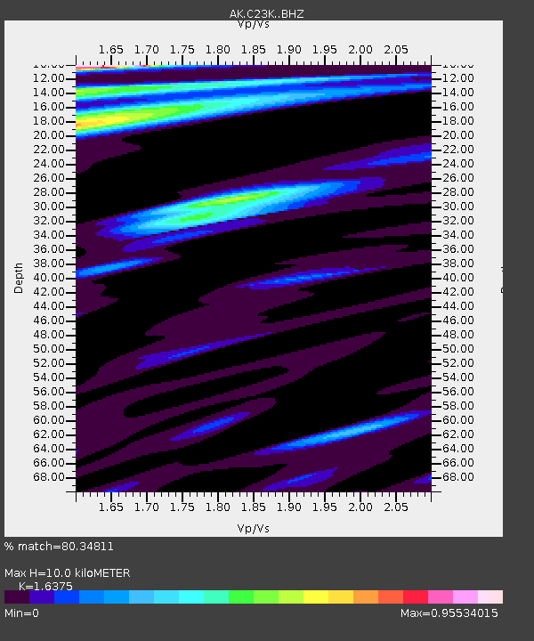
| Estimated Moho Depth: |
10.0 km |
| Estimated Crust Vp/Vs: |
1.64 |
| Assumed Crust Vp: |
6.221 km/s |
| Estimated Crust Vs: |
3.799 km/s |
| Estimated Crust Poisson's Ratio: |
0.20 |
|
| Radial Match: |
80.34811 % |
| Radial Bump: |
400 |
| Transverse Match: |
57.96287 % |
| Transverse Bump: |
400 |
| SOD ConfigId: |
27527651 |
| Insert Time: |
2022-04-23 20:54:39.353 +0000 |
| GWidth: |
2.5 |
| Max Bumps: |
400 |
| Tol: |
0.001 |
|

Signal To Noise
| Channel | StoN | STA | LTA |
| AK:C23K: :BHZ:20220409T21:05:09.699987Z | 10.935614 | 1.7411684E-6 | 1.5922001E-7 |
| AK:C23K: :BHN:20220409T21:05:09.699987Z | 0.96353936 | 2.7855197E-7 | 2.8909244E-7 |
| AK:C23K: :BHE:20220409T21:05:09.699987Z | 2.8160818 | 3.6043784E-7 | 1.2799268E-7 |
| Arrivals |
| Ps | 1.0 SECOND |
| PpPs | 4.2 SECOND |
| PsPs/PpSs | 5.2 SECOND |


