You are here: Home > Network List > AK - Alaska Regional Network Stations List
> Station F21K Alatna River, AK, USA > Earthquake Result Viewer
F21K Alatna River, AK, USA - Earthquake Result Viewer
| Earthquake location: |
Vanuatu Islands |
| Earthquake latitude/longitude: |
-16.3/166.8 |
| Earthquake time(UTC): |
2022/04/09 (099) 20:52:37 GMT |
| Earthquake Depth: |
10 km |
| Earthquake Magnitude: |
6.2 mww |
| Earthquake Catalog/Contributor: |
NEIC PDE/us |
|
| Network: |
AK Alaska Regional Network |
| Station: |
F21K Alatna River, AK, USA |
| Lat/Lon: |
67.22 N/153.48 W |
| Elevation: |
597 m |
|
| Distance: |
88.2 deg |
| Az: |
14.4 deg |
| Baz: |
217.827 deg |
| Ray Param: |
0.042731255 |
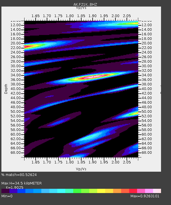
| Estimated Moho Depth: |
34.5 km |
| Estimated Crust Vp/Vs: |
1.90 |
| Assumed Crust Vp: |
6.455 km/s |
| Estimated Crust Vs: |
3.393 km/s |
| Estimated Crust Poisson's Ratio: |
0.31 |
|
| Radial Match: |
80.52624 % |
| Radial Bump: |
400 |
| Transverse Match: |
72.35567 % |
| Transverse Bump: |
400 |
| SOD ConfigId: |
27527651 |
| Insert Time: |
2022-04-23 20:55:19.966 +0000 |
| GWidth: |
2.5 |
| Max Bumps: |
400 |
| Tol: |
0.001 |
|

Signal To Noise
| Channel | StoN | STA | LTA |
| AK:F21K: :BHZ:20220409T21:04:57.11997Z | 16.75156 | 1.2582848E-6 | 7.511448E-8 |
| AK:F21K: :BHN:20220409T21:04:57.11997Z | 3.1325018 | 2.3569586E-7 | 7.524205E-8 |
| AK:F21K: :BHE:20220409T21:04:57.11997Z | 3.9718285 | 1.9197367E-7 | 4.8333828E-8 |
| Arrivals |
| Ps | 4.9 SECOND |
| PpPs | 15 SECOND |
| PsPs/PpSs | 20 SECOND |


