You are here: Home > Network List > AK - Alaska Regional Network Stations List
> Station M20K Styx River, AK, USA > Earthquake Result Viewer
M20K Styx River, AK, USA - Earthquake Result Viewer
| Earthquake location: |
Vanuatu Islands |
| Earthquake latitude/longitude: |
-16.3/166.8 |
| Earthquake time(UTC): |
2022/04/09 (099) 20:52:37 GMT |
| Earthquake Depth: |
10 km |
| Earthquake Magnitude: |
6.2 mww |
| Earthquake Catalog/Contributor: |
NEIC PDE/us |
|
| Network: |
AK Alaska Regional Network |
| Station: |
M20K Styx River, AK, USA |
| Lat/Lon: |
61.88 N/153.13 W |
| Elevation: |
1107 m |
|
| Distance: |
84.1 deg |
| Az: |
17.835 deg |
| Baz: |
218.373 deg |
| Ray Param: |
0.045707863 |
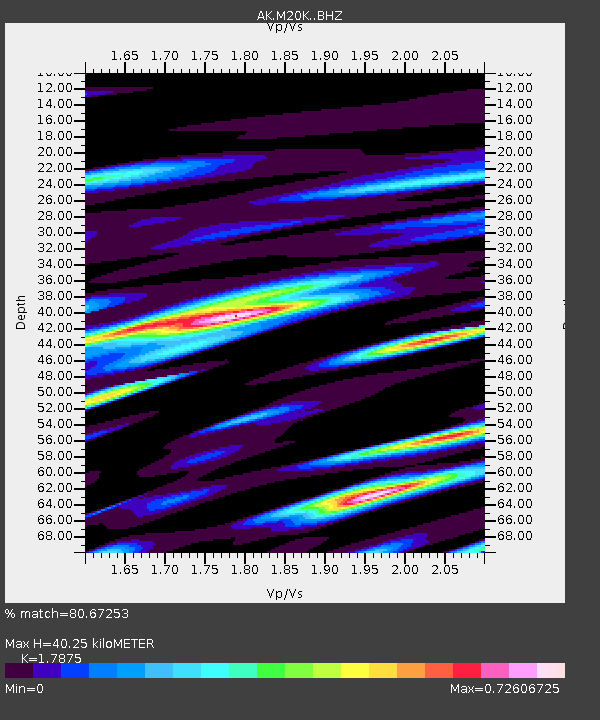
| Estimated Moho Depth: |
40.25 km |
| Estimated Crust Vp/Vs: |
1.79 |
| Assumed Crust Vp: |
6.566 km/s |
| Estimated Crust Vs: |
3.673 km/s |
| Estimated Crust Poisson's Ratio: |
0.27 |
|
| Radial Match: |
80.67253 % |
| Radial Bump: |
400 |
| Transverse Match: |
80.62821 % |
| Transverse Bump: |
400 |
| SOD ConfigId: |
27527651 |
| Insert Time: |
2022-04-23 20:56:48.442 +0000 |
| GWidth: |
2.5 |
| Max Bumps: |
400 |
| Tol: |
0.001 |
|

Signal To Noise
| Channel | StoN | STA | LTA |
| AK:M20K: :BHZ:20220409T21:04:36.840002Z | 15.4744835 | 1.7075976E-6 | 1.1034925E-7 |
| AK:M20K: :BHN:20220409T21:04:36.840002Z | 4.7380886 | 5.371511E-7 | 1.1336874E-7 |
| AK:M20K: :BHE:20220409T21:04:36.840002Z | 4.59547 | 4.513898E-7 | 9.822496E-8 |
| Arrivals |
| Ps | 5.0 SECOND |
| PpPs | 17 SECOND |
| PsPs/PpSs | 22 SECOND |


