You are here: Home > Network List > IW - Intermountain West Stations List
> Station MOOW Moose Ponds, Wyoming, USA > Earthquake Result Viewer
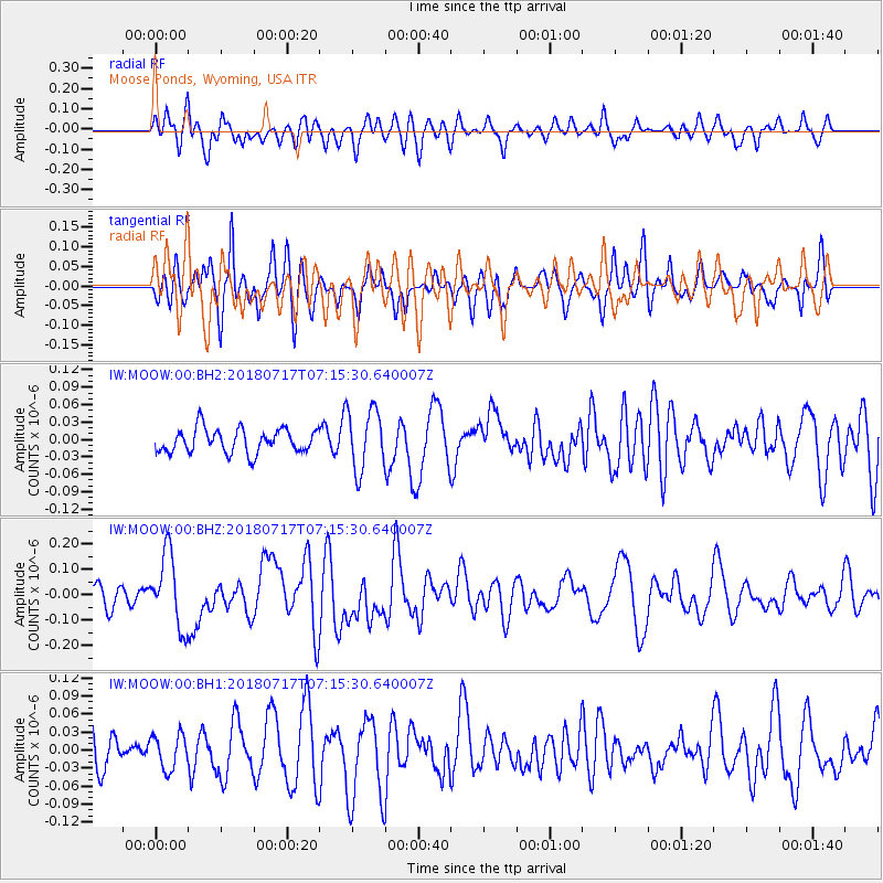
MOOW Moose Ponds, Wyoming, USA - Earthquake Result Viewer
*The percent match for this event was below the threshold and hence no stack was calculated.
| Earthquake location: |
Santa Cruz Islands |
| Earthquake latitude/longitude: |
-11.7/166.3 |
| Earthquake time(UTC): |
2018/07/17 (198) 07:02:55 GMT |
| Earthquake Depth: |
60 km |
| Earthquake Magnitude: |
5.9 Mww |
| Earthquake Catalog/Contributor: |
NEIC PDE/us |
|
| Network: |
IW Intermountain West |
| Station: |
MOOW Moose Ponds, Wyoming, USA |
| Lat/Lon: |
43.75 N/110.74 W |
| Elevation: |
2128 m |
|
| Distance: |
92.9 deg |
| Az: |
46.065 deg |
| Baz: |
256.74 deg |
| Ray Param: |
$rayparam |
*The percent match for this event was below the threshold and hence was not used in the summary stack. |
|
| Radial Match: |
70.34657 % |
| Radial Bump: |
400 |
| Transverse Match: |
64.391914 % |
| Transverse Bump: |
400 |
| SOD ConfigId: |
2768671 |
| Insert Time: |
2018-07-31 07:05:23.914 +0000 |
| GWidth: |
2.5 |
| Max Bumps: |
400 |
| Tol: |
0.001 |
|
Signal To Noise
| Channel | StoN | STA | LTA |
| IW:MOOW:00:BHZ:20180717T07:15:30.640007Z | 3.6471179 | 1.4192372E-7 | 3.891394E-8 |
| IW:MOOW:00:BH1:20180717T07:15:30.640007Z | 0.78100026 | 2.8582637E-8 | 3.6597473E-8 |
| IW:MOOW:00:BH2:20180717T07:15:30.640007Z | 2.568868 | 5.2872146E-8 | 2.0581886E-8 |
| Arrivals |
| Ps | |
| PpPs | |
| PsPs/PpSs | |


