You are here: Home > Network List > TA - USArray Transportable Network (new EarthScope stations) Stations List
> Station TOLK Toolik Lake Research Station, AK, USA > Earthquake Result Viewer
TOLK Toolik Lake Research Station, AK, USA - Earthquake Result Viewer
| Earthquake location: |
Santa Cruz Islands |
| Earthquake latitude/longitude: |
-11.7/166.3 |
| Earthquake time(UTC): |
2018/07/17 (198) 07:02:55 GMT |
| Earthquake Depth: |
60 km |
| Earthquake Magnitude: |
5.9 Mww |
| Earthquake Catalog/Contributor: |
NEIC PDE/us |
|
| Network: |
TA USArray Transportable Network (new EarthScope stations) |
| Station: |
TOLK Toolik Lake Research Station, AK, USA |
| Lat/Lon: |
68.64 N/149.57 W |
| Elevation: |
760 m |
|
| Distance: |
86.0 deg |
| Az: |
14.807 deg |
| Baz: |
223.104 deg |
| Ray Param: |
0.044278555 |
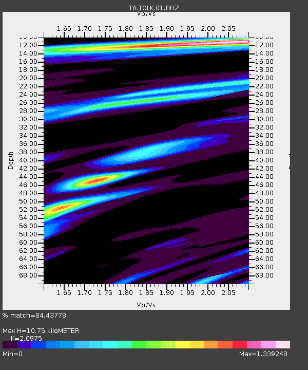
| Estimated Moho Depth: |
10.75 km |
| Estimated Crust Vp/Vs: |
2.10 |
| Assumed Crust Vp: |
6.316 km/s |
| Estimated Crust Vs: |
3.011 km/s |
| Estimated Crust Poisson's Ratio: |
0.35 |
|
| Radial Match: |
84.43778 % |
| Radial Bump: |
400 |
| Transverse Match: |
78.64385 % |
| Transverse Bump: |
400 |
| SOD ConfigId: |
2768671 |
| Insert Time: |
2018-07-31 07:05:48.201 +0000 |
| GWidth: |
2.5 |
| Max Bumps: |
400 |
| Tol: |
0.001 |
|

Signal To Noise
| Channel | StoN | STA | LTA |
| TA:TOLK:01:BHZ:20180717T07:14:57.900017Z | 9.472489 | 4.8739497E-7 | 5.1453735E-8 |
| TA:TOLK:01:BHN:20180717T07:14:57.900017Z | 2.3891943 | 9.663079E-8 | 4.044493E-8 |
| TA:TOLK:01:BHE:20180717T07:14:57.900017Z | 2.3865552 | 1.1626046E-7 | 4.871476E-8 |
| Arrivals |
| Ps | 1.9 SECOND |
| PpPs | 5.2 SECOND |
| PsPs/PpSs | 7.1 SECOND |


