You are here: Home > Network List > AV - Alaska Volcano Observatory Stations List
> Station N20K Mount Spurr, AK, USA > Earthquake Result Viewer
N20K Mount Spurr, AK, USA - Earthquake Result Viewer
| Earthquake location: |
Vanuatu Islands |
| Earthquake latitude/longitude: |
-16.3/166.8 |
| Earthquake time(UTC): |
2022/04/09 (099) 20:52:37 GMT |
| Earthquake Depth: |
10 km |
| Earthquake Magnitude: |
6.2 mww |
| Earthquake Catalog/Contributor: |
NEIC PDE/us |
|
| Network: |
AV Alaska Volcano Observatory |
| Station: |
N20K Mount Spurr, AK, USA |
| Lat/Lon: |
61.20 N/152.21 W |
| Elevation: |
991 m |
|
| Distance: |
83.9 deg |
| Az: |
18.613 deg |
| Baz: |
219.264 deg |
| Ray Param: |
0.045887303 |
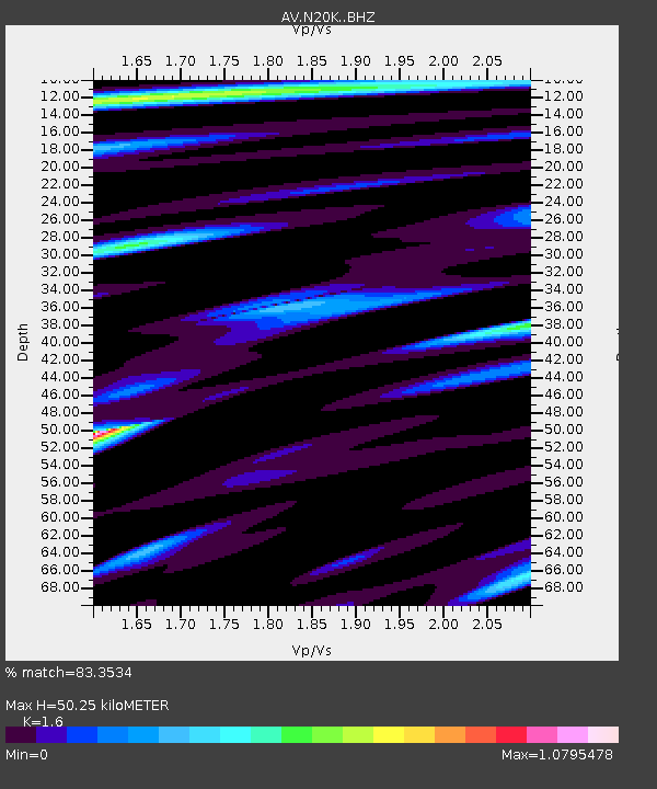
| Estimated Moho Depth: |
50.25 km |
| Estimated Crust Vp/Vs: |
1.60 |
| Assumed Crust Vp: |
6.566 km/s |
| Estimated Crust Vs: |
4.104 km/s |
| Estimated Crust Poisson's Ratio: |
0.18 |
|
| Radial Match: |
83.3534 % |
| Radial Bump: |
400 |
| Transverse Match: |
90.3188 % |
| Transverse Bump: |
400 |
| SOD ConfigId: |
27527651 |
| Insert Time: |
2022-04-23 21:01:06.556 +0000 |
| GWidth: |
2.5 |
| Max Bumps: |
400 |
| Tol: |
0.001 |
|

Signal To Noise
| Channel | StoN | STA | LTA |
| AV:N20K: :BHZ:20220409T21:04:35.550024Z | 12.479657 | 1.81259E-6 | 1.4524358E-7 |
| AV:N20K: :BHN:20220409T21:04:35.550024Z | 4.995271 | 5.54267E-7 | 1.1095833E-7 |
| AV:N20K: :BHE:20220409T21:04:35.550024Z | 3.0719466 | 4.7694147E-7 | 1.5525708E-7 |
| Arrivals |
| Ps | 4.7 SECOND |
| PpPs | 19 SECOND |
| PsPs/PpSs | 24 SECOND |


