You are here: Home > Network List > US - United States National Seismic Network Stations List
> Station MSO Missoula, Montana, USA > Earthquake Result Viewer
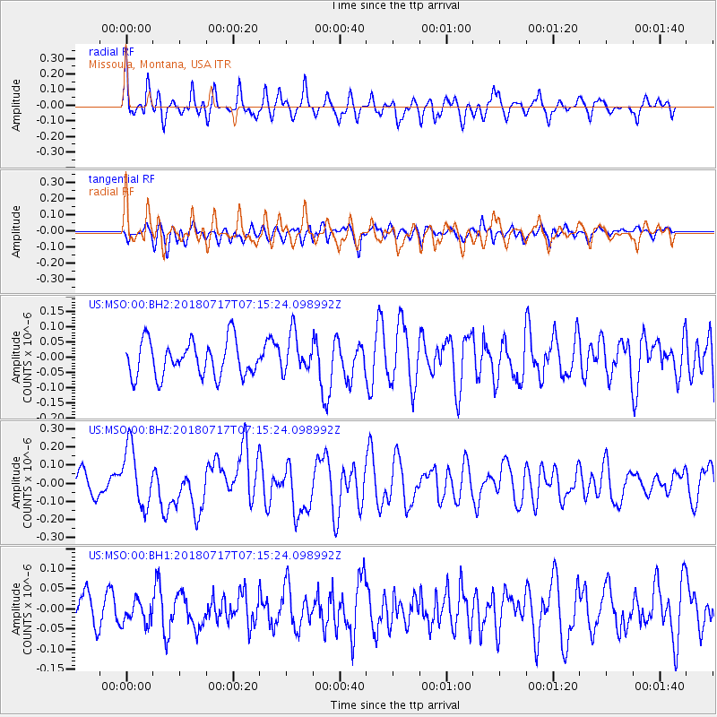
MSO Missoula, Montana, USA - Earthquake Result Viewer
*The percent match for this event was below the threshold and hence no stack was calculated.
| Earthquake location: |
Santa Cruz Islands |
| Earthquake latitude/longitude: |
-11.7/166.3 |
| Earthquake time(UTC): |
2018/07/17 (198) 07:02:55 GMT |
| Earthquake Depth: |
60 km |
| Earthquake Magnitude: |
5.9 Mww |
| Earthquake Catalog/Contributor: |
NEIC PDE/us |
|
| Network: |
US United States National Seismic Network |
| Station: |
MSO Missoula, Montana, USA |
| Lat/Lon: |
46.83 N/113.94 W |
| Elevation: |
1264 m |
|
| Distance: |
91.5 deg |
| Az: |
42.52 deg |
| Baz: |
254.614 deg |
| Ray Param: |
$rayparam |
*The percent match for this event was below the threshold and hence was not used in the summary stack. |
|
| Radial Match: |
64.73991 % |
| Radial Bump: |
400 |
| Transverse Match: |
55.486538 % |
| Transverse Bump: |
400 |
| SOD ConfigId: |
2768671 |
| Insert Time: |
2018-07-31 07:06:33.002 +0000 |
| GWidth: |
2.5 |
| Max Bumps: |
400 |
| Tol: |
0.001 |
|
Signal To Noise
| Channel | StoN | STA | LTA |
| US:MSO:00:BHZ:20180717T07:15:24.098992Z | 3.0106227 | 1.6534662E-7 | 5.492107E-8 |
| US:MSO:00:BH1:20180717T07:15:24.098992Z | 0.7062724 | 2.7667811E-8 | 3.9174417E-8 |
| US:MSO:00:BH2:20180717T07:15:24.098992Z | 1.0890565 | 6.351764E-8 | 5.8323547E-8 |
| Arrivals |
| Ps | |
| PpPs | |
| PsPs/PpSs | |


