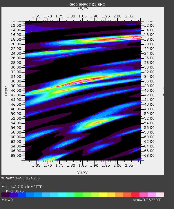
SNPC7 SNPC7 - Earthquake Result Viewer

Earthquake location: Near Coast Of Peru
Earthquake latitude/longitude: -13.5/-76.7
Earthquake time(UTC): 2006/10/20 (293) 10:48:56 GMT
Earthquake Depth: 23 km
Earthquake Magnitude: 5.9 MB, 6.6 MS, 6.7 MW, 6.6 MW
Earthquake Catalog/Contributor: WHDF/NEIC
Network: XE Sierra Nevada EarthScope Project- EarthScope Flex Array
Station: SNPC7 SNPC7
Lat/Lon: 39.31 N/120.39 W
Elevation: 2281 m
Distance: 66.4 deg
Az: 324.212 deg
Baz: 132.828 deg
Ray Param: 0.05758357
Estimated Moho Depth: 17.0 km
Estimated Crust Vp/Vs: 2.07
Assumed Crust Vp: 6.597 km/s
Estimated Crust Vs: 3.191 km/s
Estimated Crust Poisson's Ratio: 0.35
Radial Match: 95.024635 %
Radial Bump: 400
Transverse Match: 82.61381 %
Transverse Bump: 400
SOD ConfigId: 268666
Insert Time: 2010-03-09 18:32:17.555 +0000
GWidth: 2.5
Max Bumps: 400
Tol: 0.001

Signal To Noise

ChannelStoNSTALTA
XE:SNPC7:01:BHZ:20061020T10:59:12.314016Z6.29759938.4915365E-71.3483768E-7
XE:SNPC7:01:BHN:20061020T10:59:12.314016Z2.40122272.786137E-71.1602993E-7
XE:SNPC7:01:BHE:20061020T10:59:12.314016Z2.42976474.0537472E-71.6683703E-7
Arrivals
Ps2.9 SECOND
PpPs7.6 SECOND
PsPs/PpSs10 SECOND