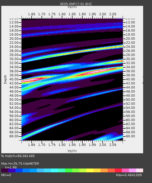
SNPC7 SNPC7 - Earthquake Result Viewer

Earthquake location: Kuril Islands
Earthquake latitude/longitude: 46.6/153.3
Earthquake time(UTC): 2006/11/15 (319) 11:14:13 GMT
Earthquake Depth: 10 km
Earthquake Magnitude: 6.5 MB, 7.8 MS, 8.3 MW, 7.9 MW
Earthquake Catalog/Contributor: WHDF/NEIC
Network: XE Sierra Nevada EarthScope Project- EarthScope Flex Array
Station: SNPC7 SNPC7
Lat/Lon: 39.31 N/120.39 W
Elevation: 2281 m
Distance: 60.6 deg
Az: 62.713 deg
Baz: 307.811 deg
Ray Param: 0.061432492
Estimated Moho Depth: 35.75 km
Estimated Crust Vp/Vs: 1.98
Assumed Crust Vp: 6.597 km/s
Estimated Crust Vs: 3.332 km/s
Estimated Crust Poisson's Ratio: 0.33
Radial Match: 96.861465 %
Radial Bump: 400
Transverse Match: 96.861465 %
Transverse Bump: 400
SOD ConfigId: 268666
Insert Time: 2010-03-09 18:32:19.922 +0000
GWidth: 2.5
Max Bumps: 400
Tol: 0.001

Signal To Noise

ChannelStoNSTALTA
XE:SNPC7:01:BHZ:20061115T11:23:53.140007Z4.74674941.1005866E-62.3186111E-7
$trig.getChannelId()$trig.getValue()$trig.getSTA()$trig.getLTA()
XE:SNPC7:01:BHE:20061115T11:23:53.140007Z2.13349374.2848933E-72.008393E-7
Arrivals
Ps5.5 SECOND
PpPs15 SECOND
PsPs/PpSs21 SECOND