You are here: Home > Network List > XE05 - Sierra Nevada EarthScope Project- EarthScope Flex Array Stations List
> Station SNPC7 SNPC7 > Earthquake Result Viewer
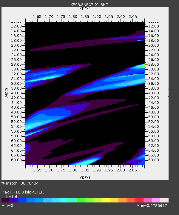
SNPC7 SNPC7 - Earthquake Result Viewer
| Earthquake location: |
East Of Kuril Islands |
| Earthquake latitude/longitude: |
47.1/155.5 |
| Earthquake time(UTC): |
2006/11/15 (319) 12:28:21 GMT |
| Earthquake Depth: |
10 km |
| Earthquake Magnitude: |
5.5 MB |
| Earthquake Catalog/Contributor: |
WHDF/NEIC |
|
| Network: |
XE Sierra Nevada EarthScope Project- EarthScope Flex Array |
| Station: |
SNPC7 SNPC7 |
| Lat/Lon: |
39.31 N/120.39 W |
| Elevation: |
2281 m |
|
| Distance: |
59.0 deg |
| Az: |
64.193 deg |
| Baz: |
307.488 deg |
| Ray Param: |
0.062482014 |
| Estimated Moho Depth: |
10.0 km |
| Estimated Crust Vp/Vs: |
1.60 |
| Assumed Crust Vp: |
6.597 km/s |
| Estimated Crust Vs: |
4.123 km/s |
| Estimated Crust Poisson's Ratio: |
0.18 |
|
| Radial Match: |
88.78484 % |
| Radial Bump: |
341 |
| Transverse Match: |
88.78491 % |
| Transverse Bump: |
341 |
| SOD ConfigId: |
268666 |
| Insert Time: |
2010-03-09 18:32:23.309 +0000 |
| GWidth: |
2.5 |
| Max Bumps: |
400 |
| Tol: |
0.001 |
|

Signal To Noise
| Channel | StoN | STA | LTA |
| XE:SNPC7:01:BHZ:20061115T12:37:49.96501Z | 0.9460425 | 1.2109952E-5 | 1.2800643E-5 |
| $trig.getChannelId() | $trig.getValue() | $trig.getSTA() | $trig.getLTA() |
| XE:SNPC7:01:BHE:20061115T12:37:49.96501Z | 1.5638782 | 1.5273048E-5 | 9.766137E-6 |
| Arrivals |
| Ps | 1.0 SECOND |
| PpPs | 3.7 SECOND |
| PsPs/PpSs | 4.7 SECOND |


