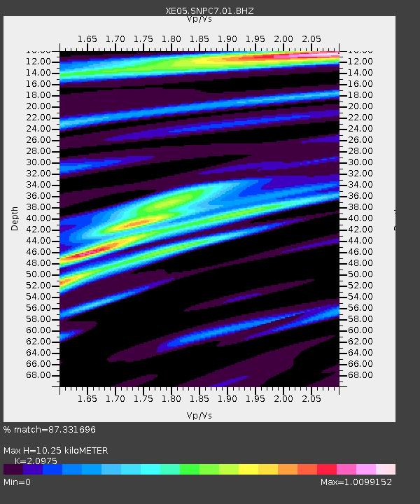
SNPC7 SNPC7 - Earthquake Result Viewer

Earthquake location: Loyalty Islands
Earthquake latitude/longitude: -20.7/168.8
Earthquake time(UTC): 2007/04/04 (094) 11:00:27 GMT
Earthquake Depth: 10 km
Earthquake Magnitude: 5.8 MB, 6.4 MS, 6.2 MW, 6.1 MW
Earthquake Catalog/Contributor: WHDF/NEIC
Network: XE Sierra Nevada EarthScope Project- EarthScope Flex Array
Station: SNPC7 SNPC7
Lat/Lon: 39.31 N/120.39 W
Elevation: 2281 m
Distance: 89.0 deg
Az: 47.109 deg
Baz: 242.145 deg
Ray Param: 0.042157486
Estimated Moho Depth: 10.25 km
Estimated Crust Vp/Vs: 2.10
Assumed Crust Vp: 6.597 km/s
Estimated Crust Vs: 3.145 km/s
Estimated Crust Poisson's Ratio: 0.35
Radial Match: 87.331696 %
Radial Bump: 400
Transverse Match: 80.37134 %
Transverse Bump: 400
SOD ConfigId: 268666
Insert Time: 2010-03-09 18:32:39.070 +0000
GWidth: 2.5
Max Bumps: 400
Tol: 0.001

Signal To Noise

ChannelStoNSTALTA
XE:SNPC7:01:BHZ:20070404T11:12:50.890012Z5.0854077.931238E-71.5596073E-7
XE:SNPC7:01:BHN:20070404T11:12:50.890012Z2.87596321.8517878E-76.438844E-8
XE:SNPC7:01:BHE:20070404T11:12:50.890012Z1.3915192.788361E-72.0038253E-7
Arrivals
Ps1.7 SECOND
PpPs4.7 SECOND
PsPs/PpSs6.5 SECOND