You are here: Home > Network List > AK - Alaska Regional Network Stations List
> Station BAT Barry Arm Top, AK, USA > Earthquake Result Viewer
BAT Barry Arm Top, AK, USA - Earthquake Result Viewer
| Earthquake location: |
New Britain Region, P.N.G. |
| Earthquake latitude/longitude: |
-4.5/152.0 |
| Earthquake time(UTC): |
2022/04/13 (103) 03:00:56 GMT |
| Earthquake Depth: |
147 km |
| Earthquake Magnitude: |
5.9 mww |
| Earthquake Catalog/Contributor: |
NEIC PDE/us |
|
| Network: |
AK Alaska Regional Network |
| Station: |
BAT Barry Arm Top, AK, USA |
| Lat/Lon: |
61.14 N/148.18 W |
| Elevation: |
1027 m |
|
| Distance: |
79.9 deg |
| Az: |
25.22 deg |
| Baz: |
241.127 deg |
| Ray Param: |
0.04830681 |
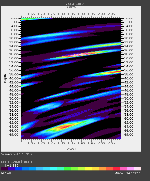
| Estimated Moho Depth: |
28.0 km |
| Estimated Crust Vp/Vs: |
1.88 |
| Assumed Crust Vp: |
6.566 km/s |
| Estimated Crust Vs: |
3.483 km/s |
| Estimated Crust Poisson's Ratio: |
0.30 |
|
| Radial Match: |
83.51237 % |
| Radial Bump: |
400 |
| Transverse Match: |
76.949814 % |
| Transverse Bump: |
400 |
| SOD ConfigId: |
27527651 |
| Insert Time: |
2022-04-27 03:08:02.293 +0000 |
| GWidth: |
2.5 |
| Max Bumps: |
400 |
| Tol: |
0.001 |
|

Signal To Noise
| Channel | StoN | STA | LTA |
| AK:BAT: :BHZ:20220413T03:12:17.560018Z | 10.640742 | 1.0552071E-6 | 9.9166684E-8 |
| AK:BAT: :BHN:20220413T03:12:17.560018Z | 4.0736976 | 2.9545333E-7 | 7.2527065E-8 |
| AK:BAT: :BHE:20220413T03:12:17.560018Z | 12.152368 | 6.614567E-7 | 5.443027E-8 |
| Arrivals |
| Ps | 3.9 SECOND |
| PpPs | 12 SECOND |
| PsPs/PpSs | 16 SECOND |


