You are here: Home > Network List > NO - Norwegian Seismic Array Network Stations List
> Station SPB1 > Earthquake Result Viewer
SPB1 - Earthquake Result Viewer
| Earthquake location: |
Alaska Peninsula |
| Earthquake latitude/longitude: |
54.4/-160.7 |
| Earthquake time(UTC): |
2018/07/18 (199) 19:06:03 GMT |
| Earthquake Depth: |
28 km |
| Earthquake Magnitude: |
5.6 Mww |
| Earthquake Catalog/Contributor: |
NEIC PDE/us |
|
| Network: |
NO Norwegian Seismic Array Network |
| Station: |
SPB1 |
| Lat/Lon: |
78.18 N/16.39 E |
| Elevation: |
301 m |
|
| Distance: |
47.7 deg |
| Az: |
0.807 deg |
| Baz: |
357.712 deg |
| Ray Param: |
0.06979485 |
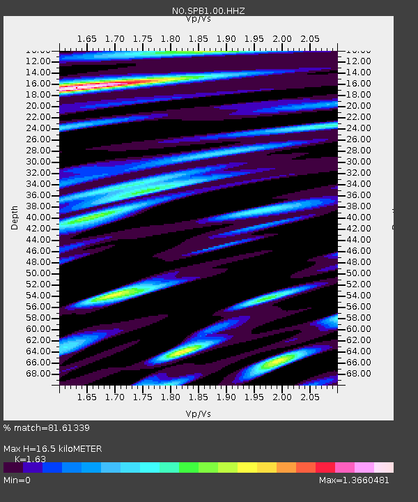
| Estimated Moho Depth: |
16.5 km |
| Estimated Crust Vp/Vs: |
1.63 |
| Assumed Crust Vp: |
6.545 km/s |
| Estimated Crust Vs: |
4.016 km/s |
| Estimated Crust Poisson's Ratio: |
0.20 |
|
| Radial Match: |
81.61339 % |
| Radial Bump: |
400 |
| Transverse Match: |
70.849556 % |
| Transverse Bump: |
400 |
| SOD ConfigId: |
2768671 |
| Insert Time: |
2018-08-01 19:11:16.053 +0000 |
| GWidth: |
2.5 |
| Max Bumps: |
400 |
| Tol: |
0.001 |
|
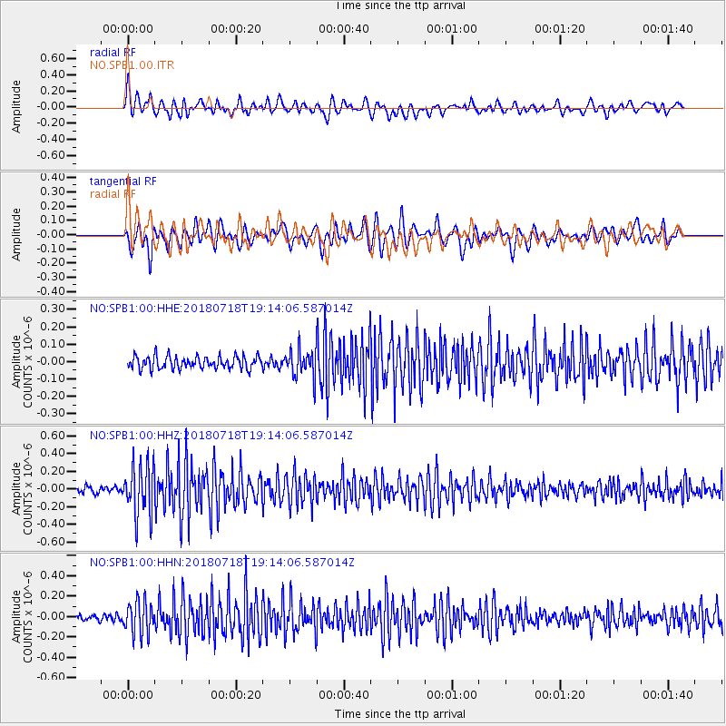
Signal To Noise
| Channel | StoN | STA | LTA |
| NO:SPB1:00:HHZ:20180718T19:14:06.587014Z | 7.8767214 | 2.9129833E-7 | 3.698218E-8 |
| NO:SPB1:00:HHN:20180718T19:14:06.587014Z | 4.340471 | 1.6243779E-7 | 3.7424E-8 |
| NO:SPB1:00:HHE:20180718T19:14:06.587014Z | 2.201639 | 7.9200056E-8 | 3.5973226E-8 |
| Arrivals |
| Ps | 1.7 SECOND |
| PpPs | 6.2 SECOND |
| PsPs/PpSs | 7.9 SECOND |


