You are here: Home > Network List > MM - Myanmar National Seismic Network Stations List
> Station KTN Keng Tun, Shan, Myanmar > Earthquake Result Viewer
KTN Keng Tun, Shan, Myanmar - Earthquake Result Viewer
| Earthquake location: |
New Britain Region, P.N.G. |
| Earthquake latitude/longitude: |
-4.5/152.0 |
| Earthquake time(UTC): |
2022/04/13 (103) 03:00:56 GMT |
| Earthquake Depth: |
147 km |
| Earthquake Magnitude: |
5.9 mww |
| Earthquake Catalog/Contributor: |
NEIC PDE/us |
|
| Network: |
MM Myanmar National Seismic Network |
| Station: |
KTN Keng Tun, Shan, Myanmar |
| Lat/Lon: |
21.29 N/99.59 E |
| Elevation: |
832 m |
|
| Distance: |
57.3 deg |
| Az: |
298.654 deg |
| Baz: |
110.257 deg |
| Ray Param: |
0.063098155 |
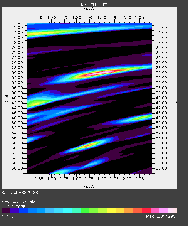
| Estimated Moho Depth: |
29.75 km |
| Estimated Crust Vp/Vs: |
1.90 |
| Assumed Crust Vp: |
6.316 km/s |
| Estimated Crust Vs: |
3.328 km/s |
| Estimated Crust Poisson's Ratio: |
0.31 |
|
| Radial Match: |
88.24381 % |
| Radial Bump: |
400 |
| Transverse Match: |
81.49573 % |
| Transverse Bump: |
400 |
| SOD ConfigId: |
27527651 |
| Insert Time: |
2022-04-27 03:19:39.666 +0000 |
| GWidth: |
2.5 |
| Max Bumps: |
400 |
| Tol: |
0.001 |
|

Signal To Noise
| Channel | StoN | STA | LTA |
| MM:KTN: :HHZ:20220413T03:09:58.248006Z | 9.674587 | 3.318264E-6 | 3.4298765E-7 |
| MM:KTN: :HHN:20220413T03:09:58.248006Z | 2.5093157 | 1.1146296E-6 | 4.4419667E-7 |
| MM:KTN: :HHE:20220413T03:09:58.248006Z | 4.60167 | 2.1895507E-6 | 4.7581656E-7 |
| Arrivals |
| Ps | 4.4 SECOND |
| PpPs | 13 SECOND |
| PsPs/PpSs | 17 SECOND |


