You are here: Home > Network List > NN - Western Great Basin/Eastern Sierra Nevada Stations List
> Station ZPR Zephyr Cove, Lake Tahoe, Nevada > Earthquake Result Viewer
ZPR Zephyr Cove, Lake Tahoe, Nevada - Earthquake Result Viewer
| Earthquake location: |
South Of Tonga Islands |
| Earthquake latitude/longitude: |
-25.2/-175.3 |
| Earthquake time(UTC): |
2022/04/14 (104) 07:03:35 GMT |
| Earthquake Depth: |
10 km |
| Earthquake Magnitude: |
5.5 Mww |
| Earthquake Catalog/Contributor: |
NEIC PDE/us |
|
| Network: |
NN Western Great Basin/Eastern Sierra Nevada |
| Station: |
ZPR Zephyr Cove, Lake Tahoe, Nevada |
| Lat/Lon: |
39.01 N/119.94 W |
| Elevation: |
2001 m |
|
| Distance: |
82.2 deg |
| Az: |
40.311 deg |
| Baz: |
228.797 deg |
| Ray Param: |
0.047067557 |
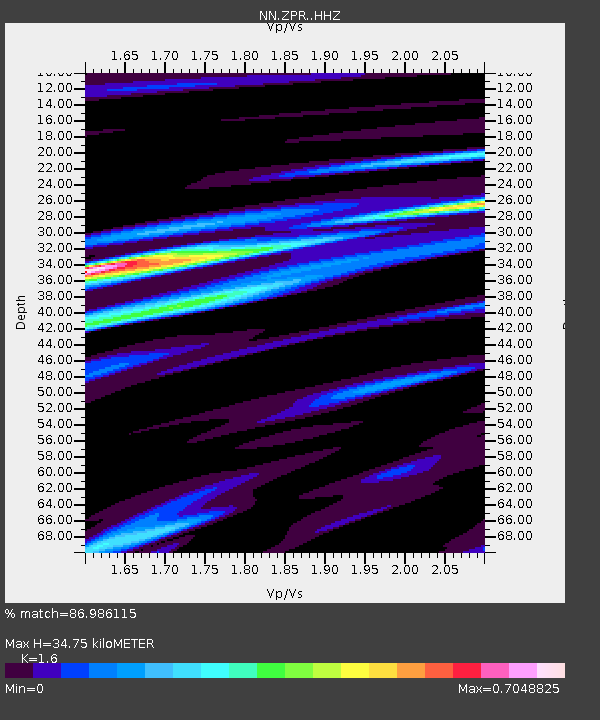
| Estimated Moho Depth: |
34.75 km |
| Estimated Crust Vp/Vs: |
1.60 |
| Assumed Crust Vp: |
6.279 km/s |
| Estimated Crust Vs: |
3.924 km/s |
| Estimated Crust Poisson's Ratio: |
0.18 |
|
| Radial Match: |
86.986115 % |
| Radial Bump: |
312 |
| Transverse Match: |
64.45969 % |
| Transverse Bump: |
400 |
| SOD ConfigId: |
27527651 |
| Insert Time: |
2022-04-28 07:18:37.330 +0000 |
| GWidth: |
2.5 |
| Max Bumps: |
400 |
| Tol: |
0.001 |
|

Signal To Noise
| Channel | StoN | STA | LTA |
| NN:ZPR: :HHZ:20220414T07:15:24.637971Z | 1.2280058 | 1.8405315E-7 | 1.4987971E-7 |
| NN:ZPR: :HHN:20220414T07:15:24.637971Z | 1.2837005 | 2.1742697E-7 | 1.6937516E-7 |
| NN:ZPR: :HHE:20220414T07:15:24.637971Z | 0.7264412 | 1.8063018E-7 | 2.486508E-7 |
| Arrivals |
| Ps | 3.4 SECOND |
| PpPs | 14 SECOND |
| PsPs/PpSs | 17 SECOND |


