You are here: Home > Network List > NE - New England Seismic Network Stations List
> Station EMMW Machias, ME, USA > Earthquake Result Viewer
EMMW Machias, ME, USA - Earthquake Result Viewer

| Earthquake location: |
Oaxaca, Mexico |
| Earthquake latitude/longitude: |
17.8/-97.8 |
| Earthquake time(UTC): |
2018/07/19 (200) 13:31:53 GMT |
| Earthquake Depth: |
55 km |
| Earthquake Magnitude: |
5.7 Mww |
| Earthquake Catalog/Contributor: |
NEIC PDE/us |
|
| Network: |
NE New England Seismic Network |
| Station: |
EMMW Machias, ME, USA |
| Lat/Lon: |
44.71 N/67.46 W |
| Elevation: |
35 m |
|
| Distance: |
36.9 deg |
| Az: |
36.826 deg |
| Baz: |
233.205 deg |
| Ray Param: |
0.07627481 |
| Estimated Moho Depth: |
48.75 km |
| Estimated Crust Vp/Vs: |
2.09 |
| Assumed Crust Vp: |
6.419 km/s |
| Estimated Crust Vs: |
3.068 km/s |
| Estimated Crust Poisson's Ratio: |
0.35 |
|
| Radial Match: |
82.93034 % |
| Radial Bump: |
400 |
| Transverse Match: |
62.203087 % |
| Transverse Bump: |
400 |
| SOD ConfigId: |
2778632 |
| Insert Time: |
2018-08-02 13:34:11.554 +0000 |
| GWidth: |
2.5 |
| Max Bumps: |
400 |
| Tol: |
0.001 |
|
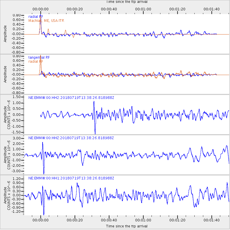
Signal To Noise
| Channel | StoN | STA | LTA |
| NE:EMMW:00:HHZ:20180719T13:38:26.818988Z | 8.647599 | 1.1471022E-6 | 1.3264979E-7 |
| NE:EMMW:00:HH1:20180719T13:38:26.818988Z | 4.191729 | 4.7200578E-7 | 1.1260407E-7 |
| NE:EMMW:00:HH2:20180719T13:38:26.818988Z | 4.0936923 | 5.454079E-7 | 1.3323128E-7 |
| Arrivals |
| Ps | 8.8 SECOND |
| PpPs | 22 SECOND |
| PsPs/PpSs | 31 SECOND |


