You are here: Home > Network List > AV - Alaska Volcano Observatory Stations List
> Station MAPS Pakushin Southeast, Makushin Volcano, Alaska > Earthquake Result Viewer
MAPS Pakushin Southeast, Makushin Volcano, Alaska - Earthquake Result Viewer
| Earthquake location: |
Vanuatu Islands |
| Earthquake latitude/longitude: |
-15.7/167.8 |
| Earthquake time(UTC): |
2022/04/17 (107) 07:46:36 GMT |
| Earthquake Depth: |
199 km |
| Earthquake Magnitude: |
5.8 Mww |
| Earthquake Catalog/Contributor: |
NEIC PDE/us |
|
| Network: |
AV Alaska Volcano Observatory |
| Station: |
MAPS Pakushin Southeast, Makushin Volcano, Alaska |
| Lat/Lon: |
53.81 N/166.94 W |
| Elevation: |
333 m |
|
| Distance: |
72.5 deg |
| Az: |
15.402 deg |
| Baz: |
205.553 deg |
| Ray Param: |
0.053070176 |
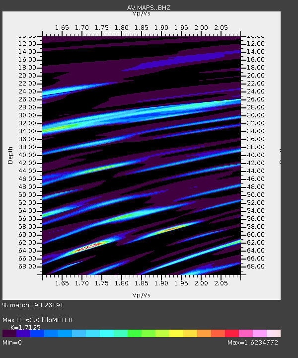
| Estimated Moho Depth: |
63.0 km |
| Estimated Crust Vp/Vs: |
1.71 |
| Assumed Crust Vp: |
3.943 km/s |
| Estimated Crust Vs: |
2.303 km/s |
| Estimated Crust Poisson's Ratio: |
0.24 |
|
| Radial Match: |
98.26191 % |
| Radial Bump: |
123 |
| Transverse Match: |
98.1921 % |
| Transverse Bump: |
104 |
| SOD ConfigId: |
27527651 |
| Insert Time: |
2022-05-01 07:53:00.527 +0000 |
| GWidth: |
2.5 |
| Max Bumps: |
400 |
| Tol: |
0.001 |
|

Signal To Noise
| Channel | StoN | STA | LTA |
| AV:MAPS: :BHZ:20220417T07:57:10.459997Z | 1.1131443 | 2.704725E-9 | 2.4298064E-9 |
| AV:MAPS: :BHN:20220417T07:57:10.459997Z | 1.1919029 | 1.5247462E-8 | 1.2792537E-8 |
| AV:MAPS: :BHE:20220417T07:57:10.459997Z | 1.1697196 | 1.6699328E-8 | 1.4276351E-8 |
| Arrivals |
| Ps | 12 SECOND |
| PpPs | 43 SECOND |
| PsPs/PpSs | 54 SECOND |


