You are here: Home > Network List > US - United States National Seismic Network Stations List
> Station MNTX Cornudas Mountains, Texas, USA > Earthquake Result Viewer
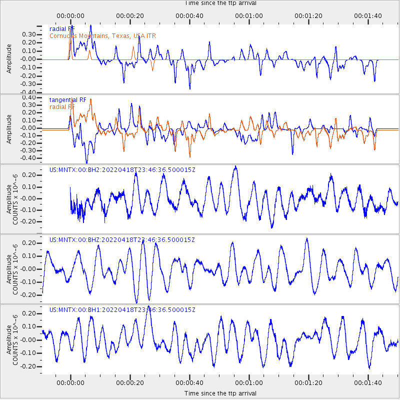
MNTX Cornudas Mountains, Texas, USA - Earthquake Result Viewer
*The percent match for this event was below the threshold and hence no stack was calculated.
| Earthquake location: |
Solomon Islands |
| Earthquake latitude/longitude: |
-11.3/162.8 |
| Earthquake time(UTC): |
2022/04/18 (108) 23:33:35 GMT |
| Earthquake Depth: |
15 km |
| Earthquake Magnitude: |
5.6 Mww |
| Earthquake Catalog/Contributor: |
NEIC PDE/us |
|
| Network: |
US United States National Seismic Network |
| Station: |
MNTX Cornudas Mountains, Texas, USA |
| Lat/Lon: |
31.70 N/105.38 W |
| Elevation: |
405 m |
|
| Distance: |
97.4 deg |
| Az: |
59.215 deg |
| Baz: |
261.349 deg |
| Ray Param: |
$rayparam |
*The percent match for this event was below the threshold and hence was not used in the summary stack. |
|
| Radial Match: |
51.16634 % |
| Radial Bump: |
400 |
| Transverse Match: |
42.994896 % |
| Transverse Bump: |
400 |
| SOD ConfigId: |
27527651 |
| Insert Time: |
2022-05-02 23:47:56.850 +0000 |
| GWidth: |
2.5 |
| Max Bumps: |
400 |
| Tol: |
0.001 |
|
Signal To Noise
| Channel | StoN | STA | LTA |
| US:MNTX:00:BHZ:20220418T23:46:36.500015Z | 1.0071929 | 7.714247E-8 | 7.6591554E-8 |
| US:MNTX:00:BH1:20220418T23:46:36.500015Z | 1.1165407 | 1.1746499E-7 | 1.0520439E-7 |
| US:MNTX:00:BH2:20220418T23:46:36.500015Z | 1.3922948 | 1.1979066E-7 | 8.6038284E-8 |
| Arrivals |
| Ps | |
| PpPs | |
| PsPs/PpSs | |


