You are here: Home > Network List > XE05 - Sierra Nevada EarthScope Project- EarthScope Flex Array Stations List
> Station SNPD5 SNPD5 > Earthquake Result Viewer
SNPD5 SNPD5 - Earthquake Result Viewer
| Earthquake location: |
Sea Of Japan |
| Earthquake latitude/longitude: |
41.4/135.7 |
| Earthquake time(UTC): |
2006/09/16 (259) 02:22:50 GMT |
| Earthquake Depth: |
367 km |
| Earthquake Magnitude: |
5.4 MB, 5.9 MW, 5.9 MW |
| Earthquake Catalog/Contributor: |
WHDF/NEIC |
|
| Network: |
XE Sierra Nevada EarthScope Project- EarthScope Flex Array |
| Station: |
SNPD5 SNPD5 |
| Lat/Lon: |
39.19 N/120.93 W |
| Elevation: |
792 m |
|
| Distance: |
73.8 deg |
| Az: |
51.934 deg |
| Baz: |
310.304 deg |
| Ray Param: |
0.05168871 |
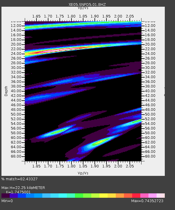
| Estimated Moho Depth: |
22.25 km |
| Estimated Crust Vp/Vs: |
1.75 |
| Assumed Crust Vp: |
6.597 km/s |
| Estimated Crust Vs: |
3.775 km/s |
| Estimated Crust Poisson's Ratio: |
0.26 |
|
| Radial Match: |
82.43327 % |
| Radial Bump: |
385 |
| Transverse Match: |
52.238113 % |
| Transverse Bump: |
400 |
| SOD ConfigId: |
268666 |
| Insert Time: |
2010-03-09 18:44:59.978 +0000 |
| GWidth: |
2.5 |
| Max Bumps: |
400 |
| Tol: |
0.001 |
|

Signal To Noise
| Channel | StoN | STA | LTA |
| XE:SNPD5:01:BHZ:20060916T02:33:14.789006Z | 9.016788 | 9.5339294E-7 | 1.0573532E-7 |
| XE:SNPD5:01:BHN:20060916T02:33:14.789006Z | 1.3701366 | 1.9458936E-7 | 1.4202186E-7 |
| XE:SNPD5:01:BHE:20060916T02:33:14.789006Z | 2.6433778 | 2.9977113E-7 | 1.13404575E-7 |
| Arrivals |
| Ps | 2.6 SECOND |
| PpPs | 9.0 SECOND |
| PsPs/PpSs | 12 SECOND |


