You are here: Home > Network List > GS - US Geological Survey Networks Stations List
> Station KAN13 Rinehart Farm > Earthquake Result Viewer
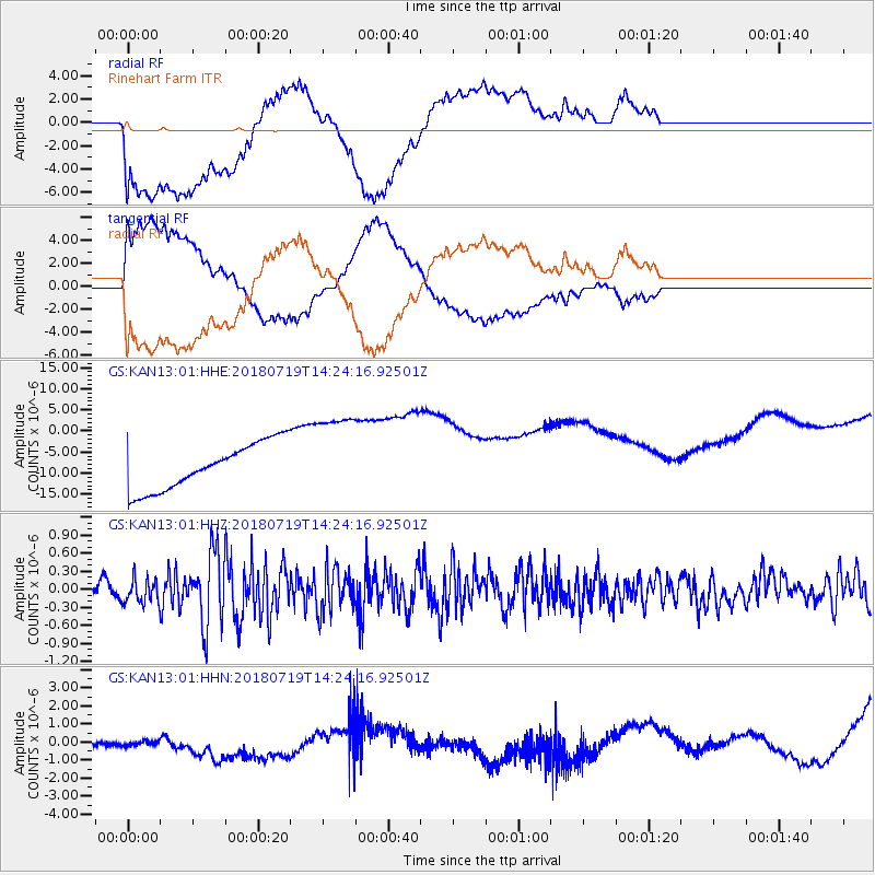
KAN13 Rinehart Farm - Earthquake Result Viewer
*The percent match for this event was below the threshold and hence no stack was calculated.
| Earthquake location: |
Alaska Peninsula |
| Earthquake latitude/longitude: |
54.4/-160.8 |
| Earthquake time(UTC): |
2018/07/19 (200) 14:16:27 GMT |
| Earthquake Depth: |
22 km |
| Earthquake Magnitude: |
5.8 Mww |
| Earthquake Catalog/Contributor: |
NEIC PDE/us |
|
| Network: |
GS US Geological Survey Networks |
| Station: |
KAN13 Rinehart Farm |
| Lat/Lon: |
37.01 N/97.48 W |
| Elevation: |
340 m |
|
| Distance: |
45.9 deg |
| Az: |
85.34 deg |
| Baz: |
313.346 deg |
| Ray Param: |
$rayparam |
*The percent match for this event was below the threshold and hence was not used in the summary stack. |
|
| Radial Match: |
33.471912 % |
| Radial Bump: |
400 |
| Transverse Match: |
32.011204 % |
| Transverse Bump: |
400 |
| SOD ConfigId: |
2778632 |
| Insert Time: |
2018-08-02 14:21:16.834 +0000 |
| GWidth: |
2.5 |
| Max Bumps: |
400 |
| Tol: |
0.001 |
|
Signal To Noise
| Channel | StoN | STA | LTA |
| GS:KAN13:01:HHZ:20180719T14:24:16.92501Z | 1.9605007 | 2.0034628E-7 | 1.0219138E-7 |
| GS:KAN13:01:HHN:20180719T14:24:16.92501Z | 1.5205034 | 8.4834215E-7 | 5.579351E-7 |
| GS:KAN13:01:HHE:20180719T14:24:16.92501Z | 1.9717987 | 1.0846687E-5 | 5.50091E-6 |
| Arrivals |
| Ps | |
| PpPs | |
| PsPs/PpSs | |


