You are here: Home > Network List > AK - Alaska Regional Network Stations List
> Station G24K Hadweenzic River, AK, USA > Earthquake Result Viewer
G24K Hadweenzic River, AK, USA - Earthquake Result Viewer
| Earthquake location: |
Mindanao, Philippines |
| Earthquake latitude/longitude: |
7.2/127.0 |
| Earthquake time(UTC): |
2022/04/19 (109) 01:23:06 GMT |
| Earthquake Depth: |
19 km |
| Earthquake Magnitude: |
6.1 mww |
| Earthquake Catalog/Contributor: |
NEIC PDE/us |
|
| Network: |
AK Alaska Regional Network |
| Station: |
G24K Hadweenzic River, AK, USA |
| Lat/Lon: |
66.70 N/147.48 W |
| Elevation: |
503 m |
|
| Distance: |
81.7 deg |
| Az: |
23.631 deg |
| Baz: |
268.813 deg |
| Ray Param: |
0.047427073 |
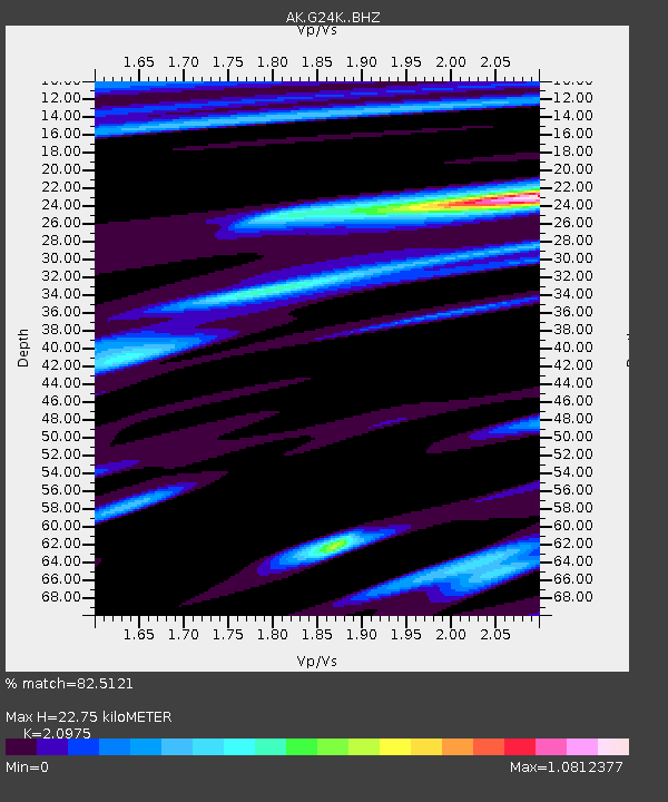
| Estimated Moho Depth: |
22.75 km |
| Estimated Crust Vp/Vs: |
2.10 |
| Assumed Crust Vp: |
6.522 km/s |
| Estimated Crust Vs: |
3.109 km/s |
| Estimated Crust Poisson's Ratio: |
0.35 |
|
| Radial Match: |
82.5121 % |
| Radial Bump: |
400 |
| Transverse Match: |
59.448936 % |
| Transverse Bump: |
400 |
| SOD ConfigId: |
27527651 |
| Insert Time: |
2022-05-03 01:25:32.228 +0000 |
| GWidth: |
2.5 |
| Max Bumps: |
400 |
| Tol: |
0.001 |
|

Signal To Noise
| Channel | StoN | STA | LTA |
| AK:G24K: :BHZ:20220419T01:34:52.240011Z | 4.131268 | 8.036218E-7 | 1.945218E-7 |
| AK:G24K: :BHN:20220419T01:34:52.240011Z | 2.320833 | 1.9442327E-7 | 8.377306E-8 |
| AK:G24K: :BHE:20220419T01:34:52.240011Z | 2.1336033 | 2.5327142E-7 | 1.18705955E-7 |
| Arrivals |
| Ps | 3.9 SECOND |
| PpPs | 11 SECOND |
| PsPs/PpSs | 14 SECOND |


