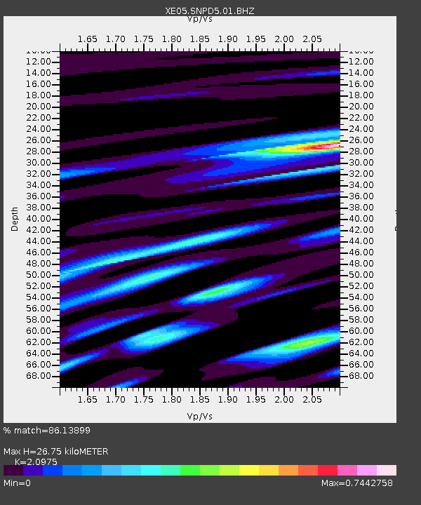
SNPD5 SNPD5 - Earthquake Result Viewer

Earthquake location: Loyalty Islands
Earthquake latitude/longitude: -20.7/168.8
Earthquake time(UTC): 2007/04/04 (094) 11:00:27 GMT
Earthquake Depth: 10 km
Earthquake Magnitude: 5.8 MB, 6.4 MS, 6.2 MW, 6.1 MW
Earthquake Catalog/Contributor: WHDF/NEIC
Network: XE Sierra Nevada EarthScope Project- EarthScope Flex Array
Station: SNPD5 SNPD5
Lat/Lon: 39.19 N/120.93 W
Elevation: 792 m
Distance: 88.6 deg
Az: 47.017 deg
Baz: 241.8 deg
Ray Param: 0.04247543
Estimated Moho Depth: 26.75 km
Estimated Crust Vp/Vs: 2.10
Assumed Crust Vp: 6.597 km/s
Estimated Crust Vs: 3.145 km/s
Estimated Crust Poisson's Ratio: 0.35
Radial Match: 86.13899 %
Radial Bump: 400
Transverse Match: 67.581696 %
Transverse Bump: 400
SOD ConfigId: 268666
Insert Time: 2010-03-09 18:45:27.751 +0000
GWidth: 2.5
Max Bumps: 400
Tol: 0.001

Signal To Noise

ChannelStoNSTALTA
XE:SNPD5:01:BHZ:20070404T11:12:48.864011Z8.8459619.3187083E-71.0534423E-7
XE:SNPD5:01:BHN:20070404T11:12:48.864011Z2.00218442.4409914E-71.2191641E-7
XE:SNPD5:01:BHE:20070404T11:12:48.864011Z2.19484782.5286192E-71.15207044E-7
Arrivals
Ps4.5 SECOND
PpPs12 SECOND
PsPs/PpSs17 SECOND