You are here: Home > Network List > XE05 - Sierra Nevada EarthScope Project- EarthScope Flex Array Stations List
> Station SNPD5 SNPD5 > Earthquake Result Viewer
SNPD5 SNPD5 - Earthquake Result Viewer
| Earthquake location: |
Sea Of Japan |
| Earthquake latitude/longitude: |
36.8/134.9 |
| Earthquake time(UTC): |
2007/07/16 (197) 14:17:37 GMT |
| Earthquake Depth: |
350 km |
| Earthquake Magnitude: |
6.2 MB, 6.8 MW, 6.8 MW |
| Earthquake Catalog/Contributor: |
WHDF/NEIC |
|
| Network: |
XE Sierra Nevada EarthScope Project- EarthScope Flex Array |
| Station: |
SNPD5 SNPD5 |
| Lat/Lon: |
39.19 N/120.93 W |
| Elevation: |
792 m |
|
| Distance: |
77.2 deg |
| Az: |
50.588 deg |
| Baz: |
307.065 deg |
| Ray Param: |
0.049528003 |
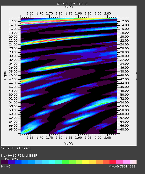
| Estimated Moho Depth: |
12.75 km |
| Estimated Crust Vp/Vs: |
1.62 |
| Assumed Crust Vp: |
6.597 km/s |
| Estimated Crust Vs: |
4.06 km/s |
| Estimated Crust Poisson's Ratio: |
0.20 |
|
| Radial Match: |
91.69261 % |
| Radial Bump: |
400 |
| Transverse Match: |
80.97913 % |
| Transverse Bump: |
400 |
| SOD ConfigId: |
268666 |
| Insert Time: |
2010-03-09 18:45:52.292 +0000 |
| GWidth: |
2.5 |
| Max Bumps: |
400 |
| Tol: |
0.001 |
|

Signal To Noise
| Channel | StoN | STA | LTA |
| XE:SNPD5:01:BHZ:20070716T14:28:22.063999Z | 34.142197 | 2.4379442E-6 | 7.140561E-8 |
| XE:SNPD5:01:BHN:20070716T14:28:22.063999Z | 11.377766 | 5.8150397E-7 | 5.11088E-8 |
| XE:SNPD5:01:BHE:20070716T14:28:22.063999Z | 9.107148 | 5.7646895E-7 | 6.329852E-8 |
| Arrivals |
| Ps | 1.2 SECOND |
| PpPs | 4.9 SECOND |
| PsPs/PpSs | 6.2 SECOND |


