You are here: Home > Network List > MM - Myanmar National Seismic Network Stations List
> Station TGI Taung Gyi, Myanmar > Earthquake Result Viewer
TGI Taung Gyi, Myanmar - Earthquake Result Viewer
| Earthquake location: |
Mindanao, Philippines |
| Earthquake latitude/longitude: |
7.2/127.0 |
| Earthquake time(UTC): |
2022/04/19 (109) 01:23:06 GMT |
| Earthquake Depth: |
19 km |
| Earthquake Magnitude: |
6.1 mww |
| Earthquake Catalog/Contributor: |
NEIC PDE/us |
|
| Network: |
MM Myanmar National Seismic Network |
| Station: |
TGI Taung Gyi, Myanmar |
| Lat/Lon: |
20.77 N/97.03 E |
| Elevation: |
1458 m |
|
| Distance: |
31.9 deg |
| Az: |
298.012 deg |
| Baz: |
110.61 deg |
| Ray Param: |
0.07887159 |
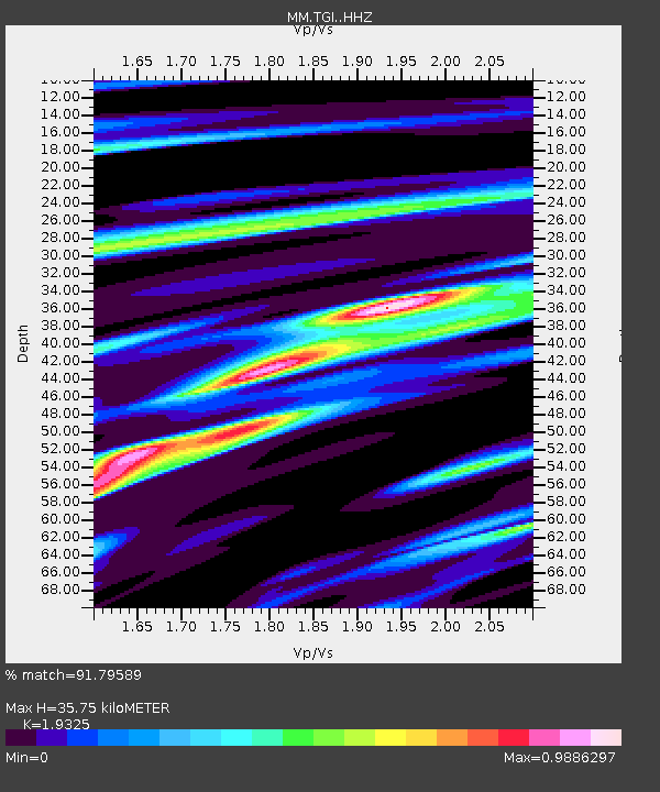
| Estimated Moho Depth: |
35.75 km |
| Estimated Crust Vp/Vs: |
1.93 |
| Assumed Crust Vp: |
6.316 km/s |
| Estimated Crust Vs: |
3.268 km/s |
| Estimated Crust Poisson's Ratio: |
0.32 |
|
| Radial Match: |
91.79589 % |
| Radial Bump: |
314 |
| Transverse Match: |
72.82526 % |
| Transverse Bump: |
400 |
| SOD ConfigId: |
27527651 |
| Insert Time: |
2022-05-03 01:35:05.630 +0000 |
| GWidth: |
2.5 |
| Max Bumps: |
400 |
| Tol: |
0.001 |
|

Signal To Noise
| Channel | StoN | STA | LTA |
| MM:TGI: :HHZ:20220419T01:29:00.460012Z | 22.646397 | 9.946284E-7 | 4.3919943E-8 |
| MM:TGI: :HHN:20220419T01:29:00.460012Z | 3.7099106 | 2.1228232E-7 | 5.722033E-8 |
| MM:TGI: :HHE:20220419T01:29:00.460012Z | 10.325942 | 6.277214E-7 | 6.079072E-8 |
| Arrivals |
| Ps | 5.7 SECOND |
| PpPs | 15 SECOND |
| PsPs/PpSs | 21 SECOND |


