You are here: Home > Network List > AK - Alaska Regional Network Stations List
> Station F15K North Star Ditch, AK, USA > Earthquake Result Viewer
F15K North Star Ditch, AK, USA - Earthquake Result Viewer
| Earthquake location: |
Tonga Islands |
| Earthquake latitude/longitude: |
-21.5/-173.9 |
| Earthquake time(UTC): |
2022/04/19 (109) 04:33:41 GMT |
| Earthquake Depth: |
10 km |
| Earthquake Magnitude: |
6.0 mww |
| Earthquake Catalog/Contributor: |
NEIC PDE/us |
|
| Network: |
AK Alaska Regional Network |
| Station: |
F15K North Star Ditch, AK, USA |
| Lat/Lon: |
65.71 N/164.65 W |
| Elevation: |
388 m |
|
| Distance: |
87.2 deg |
| Az: |
3.824 deg |
| Baz: |
188.638 deg |
| Ray Param: |
0.043517075 |
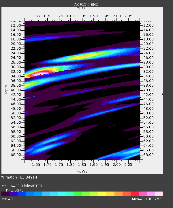
| Estimated Moho Depth: |
33.0 km |
| Estimated Crust Vp/Vs: |
1.67 |
| Assumed Crust Vp: |
6.276 km/s |
| Estimated Crust Vs: |
3.764 km/s |
| Estimated Crust Poisson's Ratio: |
0.22 |
|
| Radial Match: |
81.34914 % |
| Radial Bump: |
348 |
| Transverse Match: |
58.123196 % |
| Transverse Bump: |
400 |
| SOD ConfigId: |
27527651 |
| Insert Time: |
2022-05-03 04:37:29.481 +0000 |
| GWidth: |
2.5 |
| Max Bumps: |
400 |
| Tol: |
0.001 |
|

Signal To Noise
| Channel | StoN | STA | LTA |
| AK:F15K: :BHZ:20220419T04:45:56.300002Z | 5.2777734 | 9.0341496E-7 | 1.7117351E-7 |
| AK:F15K: :BHN:20220419T04:45:56.300002Z | 2.731305 | 3.9477743E-7 | 1.4453802E-7 |
| AK:F15K: :BHE:20220419T04:45:56.300002Z | 0.6238243 | 6.544065E-8 | 1.04902384E-7 |
| Arrivals |
| Ps | 3.6 SECOND |
| PpPs | 14 SECOND |
| PsPs/PpSs | 17 SECOND |


