You are here: Home > Network List > AK - Alaska Regional Network Stations List
> Station M20K Styx River, AK, USA > Earthquake Result Viewer
M20K Styx River, AK, USA - Earthquake Result Viewer
| Earthquake location: |
Tonga Islands |
| Earthquake latitude/longitude: |
-21.5/-173.9 |
| Earthquake time(UTC): |
2022/04/19 (109) 04:33:41 GMT |
| Earthquake Depth: |
10 km |
| Earthquake Magnitude: |
6.0 mww |
| Earthquake Catalog/Contributor: |
NEIC PDE/us |
|
| Network: |
AK Alaska Regional Network |
| Station: |
M20K Styx River, AK, USA |
| Lat/Lon: |
61.88 N/153.13 W |
| Elevation: |
1107 m |
|
| Distance: |
84.7 deg |
| Az: |
9.719 deg |
| Baz: |
199.388 deg |
| Ray Param: |
0.045302495 |
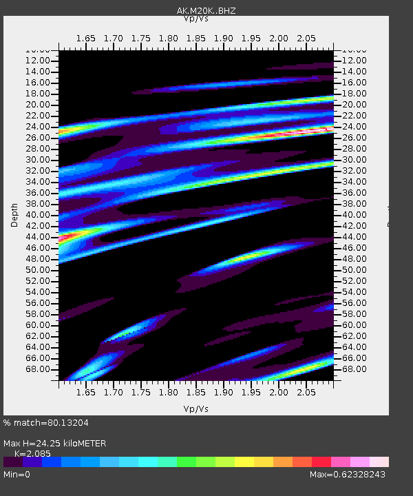
| Estimated Moho Depth: |
24.25 km |
| Estimated Crust Vp/Vs: |
2.09 |
| Assumed Crust Vp: |
6.566 km/s |
| Estimated Crust Vs: |
3.149 km/s |
| Estimated Crust Poisson's Ratio: |
0.35 |
|
| Radial Match: |
80.13204 % |
| Radial Bump: |
400 |
| Transverse Match: |
60.24055 % |
| Transverse Bump: |
400 |
| SOD ConfigId: |
27527651 |
| Insert Time: |
2022-05-03 04:38:59.124 +0000 |
| GWidth: |
2.5 |
| Max Bumps: |
400 |
| Tol: |
0.001 |
|

Signal To Noise
| Channel | StoN | STA | LTA |
| AK:M20K: :BHZ:20220419T04:45:44.09999Z | 8.282797 | 1.4262826E-6 | 1.7219818E-7 |
| AK:M20K: :BHN:20220419T04:45:44.09999Z | 3.7069786 | 1.162782E-6 | 3.136738E-7 |
| AK:M20K: :BHE:20220419T04:45:44.09999Z | 0.741192 | 2.5079126E-7 | 3.3836207E-7 |
| Arrivals |
| Ps | 4.1 SECOND |
| PpPs | 11 SECOND |
| PsPs/PpSs | 15 SECOND |


