You are here: Home > Network List > NO - Norwegian Seismic Array Network Stations List
> Station SPB1 > Earthquake Result Viewer
SPB1 - Earthquake Result Viewer
| Earthquake location: |
Alaska Peninsula |
| Earthquake latitude/longitude: |
54.4/-160.8 |
| Earthquake time(UTC): |
2018/07/19 (200) 14:16:27 GMT |
| Earthquake Depth: |
22 km |
| Earthquake Magnitude: |
5.8 Mww |
| Earthquake Catalog/Contributor: |
NEIC PDE/us |
|
| Network: |
NO Norwegian Seismic Array Network |
| Station: |
SPB1 |
| Lat/Lon: |
78.18 N/16.39 E |
| Elevation: |
301 m |
|
| Distance: |
47.6 deg |
| Az: |
0.786 deg |
| Baz: |
357.774 deg |
| Ray Param: |
0.06984186 |
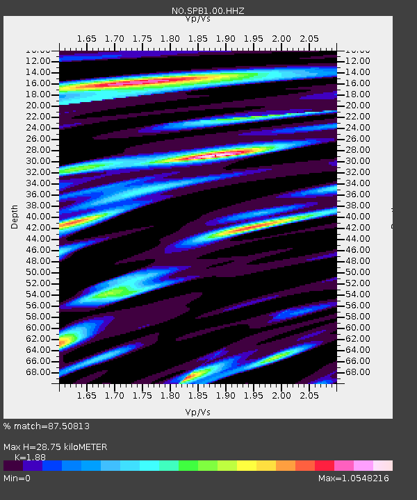
| Estimated Moho Depth: |
28.75 km |
| Estimated Crust Vp/Vs: |
1.88 |
| Assumed Crust Vp: |
6.545 km/s |
| Estimated Crust Vs: |
3.482 km/s |
| Estimated Crust Poisson's Ratio: |
0.30 |
|
| Radial Match: |
87.50813 % |
| Radial Bump: |
400 |
| Transverse Match: |
83.39958 % |
| Transverse Bump: |
400 |
| SOD ConfigId: |
2778632 |
| Insert Time: |
2018-08-02 14:24:54.012 +0000 |
| GWidth: |
2.5 |
| Max Bumps: |
400 |
| Tol: |
0.001 |
|
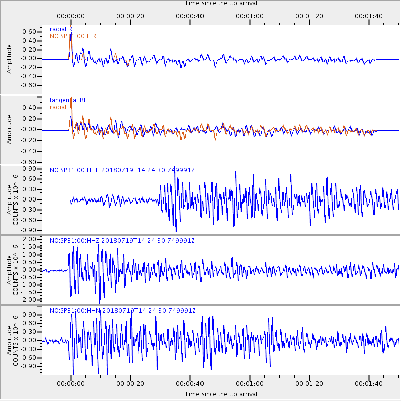
Signal To Noise
| Channel | StoN | STA | LTA |
| NO:SPB1:00:HHZ:20180719T14:24:30.749991Z | 19.068806 | 9.504671E-7 | 4.984408E-8 |
| NO:SPB1:00:HHN:20180719T14:24:30.749991Z | 9.808657 | 5.210726E-7 | 5.312375E-8 |
| NO:SPB1:00:HHE:20180719T14:24:30.749991Z | 5.0671372 | 3.3743225E-7 | 6.6592285E-8 |
| Arrivals |
| Ps | 4.1 SECOND |
| PpPs | 12 SECOND |
| PsPs/PpSs | 16 SECOND |


