You are here: Home > Network List > NO - Norwegian Seismic Array Network Stations List
> Station SPB5 > Earthquake Result Viewer
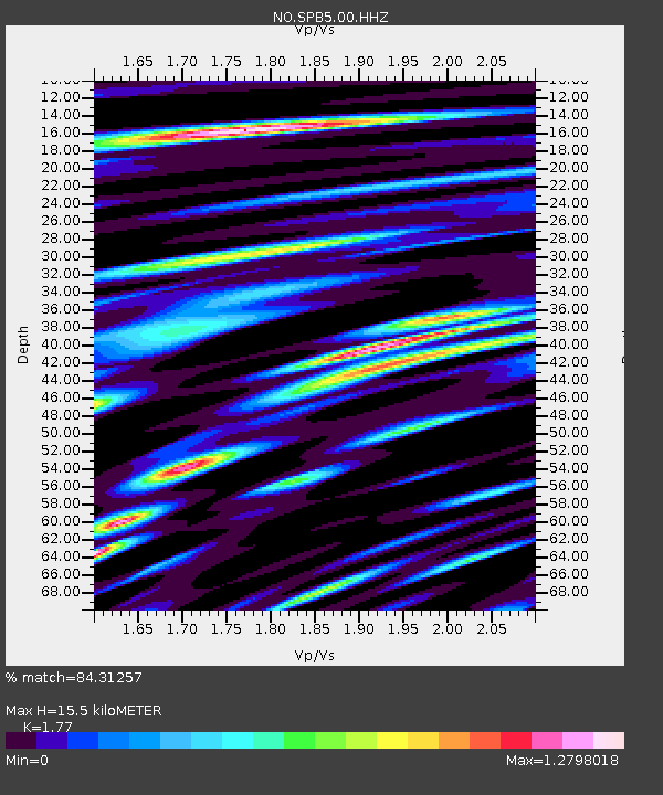
SPB5 - Earthquake Result Viewer
| Earthquake location: |
Alaska Peninsula |
| Earthquake latitude/longitude: |
54.4/-160.8 |
| Earthquake time(UTC): |
2018/07/19 (200) 14:16:27 GMT |
| Earthquake Depth: |
22 km |
| Earthquake Magnitude: |
5.8 Mww |
| Earthquake Catalog/Contributor: |
NEIC PDE/us |
|
| Network: |
NO Norwegian Seismic Array Network |
| Station: |
SPB5 |
| Lat/Lon: |
78.18 N/16.37 E |
| Elevation: |
295 m |
|
| Distance: |
47.6 deg |
| Az: |
0.792 deg |
| Baz: |
357.756 deg |
| Ray Param: |
0.069843695 |
| Estimated Moho Depth: |
15.5 km |
| Estimated Crust Vp/Vs: |
1.77 |
| Assumed Crust Vp: |
6.545 km/s |
| Estimated Crust Vs: |
3.698 km/s |
| Estimated Crust Poisson's Ratio: |
0.27 |
|
| Radial Match: |
84.31257 % |
| Radial Bump: |
400 |
| Transverse Match: |
80.9618 % |
| Transverse Bump: |
400 |
| SOD ConfigId: |
2778632 |
| Insert Time: |
2018-08-02 14:24:59.535 +0000 |
| GWidth: |
2.5 |
| Max Bumps: |
400 |
| Tol: |
0.001 |
|

Signal To Noise
| Channel | StoN | STA | LTA |
| NO:SPB5:00:HHZ:20180719T14:24:30.724998Z | 17.800602 | 9.006825E-7 | 5.059843E-8 |
| NO:SPB5:00:HHN:20180719T14:24:30.724998Z | 9.185342 | 5.4902324E-7 | 5.977167E-8 |
| NO:SPB5:00:HHE:20180719T14:24:30.724998Z | 4.2112727 | 2.9169524E-7 | 6.926534E-8 |
| Arrivals |
| Ps | 1.9 SECOND |
| PpPs | 6.2 SECOND |
| PsPs/PpSs | 8.1 SECOND |


