You are here: Home > Network List > CI - Caltech Regional Seismic Network Stations List
> Station MPP McPhearson Peak > Earthquake Result Viewer
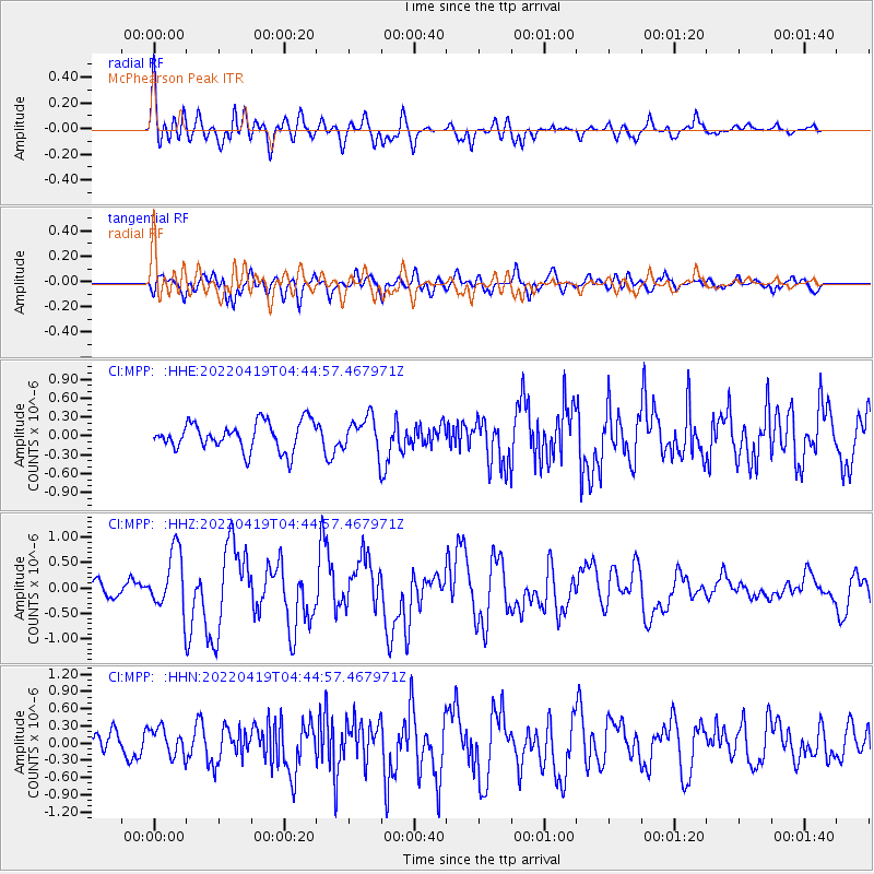
MPP McPhearson Peak - Earthquake Result Viewer
*The percent match for this event was below the threshold and hence no stack was calculated.
| Earthquake location: |
Tonga Islands |
| Earthquake latitude/longitude: |
-21.5/-173.9 |
| Earthquake time(UTC): |
2022/04/19 (109) 04:33:41 GMT |
| Earthquake Depth: |
10 km |
| Earthquake Magnitude: |
6.0 mww |
| Earthquake Catalog/Contributor: |
NEIC PDE/us |
|
| Network: |
CI Caltech Regional Seismic Network |
| Station: |
MPP McPhearson Peak |
| Lat/Lon: |
34.89 N/119.81 W |
| Elevation: |
1739 m |
|
| Distance: |
76.0 deg |
| Az: |
43.339 deg |
| Baz: |
231.054 deg |
| Ray Param: |
$rayparam |
*The percent match for this event was below the threshold and hence was not used in the summary stack. |
|
| Radial Match: |
67.47162 % |
| Radial Bump: |
400 |
| Transverse Match: |
69.63128 % |
| Transverse Bump: |
400 |
| SOD ConfigId: |
27527651 |
| Insert Time: |
2022-05-03 04:47:47.910 +0000 |
| GWidth: |
2.5 |
| Max Bumps: |
400 |
| Tol: |
0.001 |
|
Signal To Noise
| Channel | StoN | STA | LTA |
| CI:MPP: :HHZ:20220419T04:44:57.467971Z | 3.51396 | 5.8793114E-7 | 1.6731299E-7 |
| CI:MPP: :HHN:20220419T04:44:57.467971Z | 1.6361731 | 2.4351687E-7 | 1.4883318E-7 |
| CI:MPP: :HHE:20220419T04:44:57.467971Z | 1.2236394 | 2.7222953E-7 | 2.2247528E-7 |
| Arrivals |
| Ps | |
| PpPs | |
| PsPs/PpSs | |


