You are here: Home > Network List > II - Global Seismograph Network (GSN - IRIS/IDA) Stations List
> Station XPFO Pinon Flat, California, USA > Earthquake Result Viewer
XPFO Pinon Flat, California, USA - Earthquake Result Viewer
| Earthquake location: |
Tonga Islands |
| Earthquake latitude/longitude: |
-21.5/-173.9 |
| Earthquake time(UTC): |
2022/04/19 (109) 04:33:41 GMT |
| Earthquake Depth: |
10 km |
| Earthquake Magnitude: |
6.0 mww |
| Earthquake Catalog/Contributor: |
NEIC PDE/us |
|
| Network: |
II Global Seismograph Network (GSN - IRIS/IDA) |
| Station: |
XPFO Pinon Flat, California, USA |
| Lat/Lon: |
33.61 N/116.46 W |
| Elevation: |
1280 m |
|
| Distance: |
77.4 deg |
| Az: |
46.123 deg |
| Baz: |
233.576 deg |
| Ray Param: |
0.05033803 |
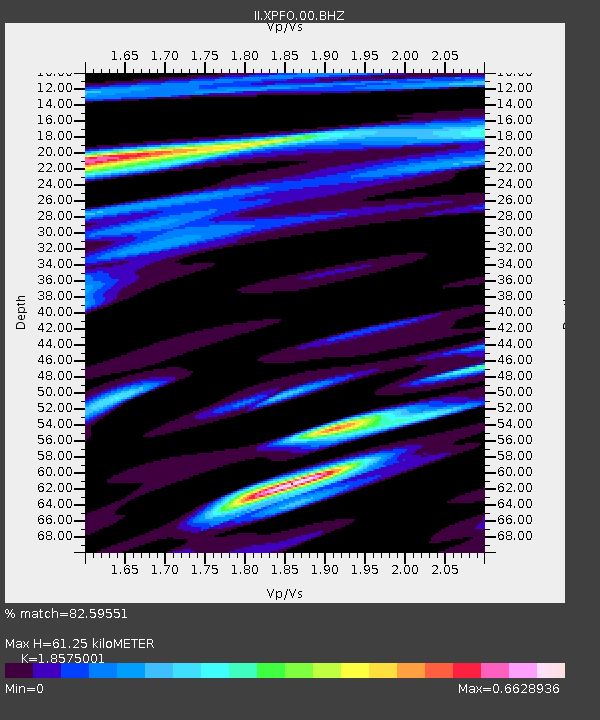
| Estimated Moho Depth: |
61.25 km |
| Estimated Crust Vp/Vs: |
1.86 |
| Assumed Crust Vp: |
6.264 km/s |
| Estimated Crust Vs: |
3.372 km/s |
| Estimated Crust Poisson's Ratio: |
0.30 |
|
| Radial Match: |
82.59551 % |
| Radial Bump: |
335 |
| Transverse Match: |
69.441414 % |
| Transverse Bump: |
400 |
| SOD ConfigId: |
27527651 |
| Insert Time: |
2022-05-03 04:52:14.807 +0000 |
| GWidth: |
2.5 |
| Max Bumps: |
400 |
| Tol: |
0.001 |
|

Signal To Noise
| Channel | StoN | STA | LTA |
| II:XPFO:00:BHZ:20220419T04:45:05.493972Z | 5.870499 | 5.337796E-7 | 9.092577E-8 |
| II:XPFO:00:BH1:20220419T04:45:05.493972Z | 1.5819849 | 1.1976319E-7 | 7.5704385E-8 |
| II:XPFO:00:BH2:20220419T04:45:05.493972Z | 1.4258353 | 1.1988907E-7 | 8.408339E-8 |
| Arrivals |
| Ps | 8.6 SECOND |
| PpPs | 27 SECOND |
| PsPs/PpSs | 36 SECOND |


