You are here: Home > Network List > XE05 - Sierra Nevada EarthScope Project- EarthScope Flex Array Stations List
> Station SNPD7 SNPD7 > Earthquake Result Viewer
SNPD7 SNPD7 - Earthquake Result Viewer
| Earthquake location: |
Kuril Islands |
| Earthquake latitude/longitude: |
46.9/153.7 |
| Earthquake time(UTC): |
2006/11/15 (319) 11:33:23 GMT |
| Earthquake Depth: |
10 km |
| Earthquake Magnitude: |
5.5 MB |
| Earthquake Catalog/Contributor: |
WHDF/NEIC |
|
| Network: |
XE Sierra Nevada EarthScope Project- EarthScope Flex Array |
| Station: |
SNPD7 SNPD7 |
| Lat/Lon: |
39.62 N/120.58 W |
| Elevation: |
1669 m |
|
| Distance: |
59.9 deg |
| Az: |
62.924 deg |
| Baz: |
307.711 deg |
| Ray Param: |
0.061900612 |
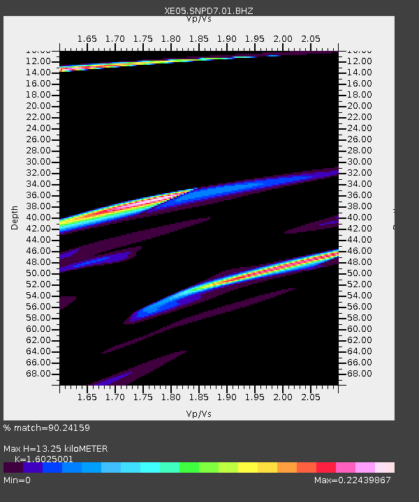
| Estimated Moho Depth: |
13.25 km |
| Estimated Crust Vp/Vs: |
1.60 |
| Assumed Crust Vp: |
6.597 km/s |
| Estimated Crust Vs: |
4.117 km/s |
| Estimated Crust Poisson's Ratio: |
0.18 |
|
| Radial Match: |
90.24159 % |
| Radial Bump: |
320 |
| Transverse Match: |
40.551796 % |
| Transverse Bump: |
400 |
| SOD ConfigId: |
268666 |
| Insert Time: |
2010-03-09 18:49:21.776 +0000 |
| GWidth: |
2.5 |
| Max Bumps: |
400 |
| Tol: |
0.001 |
|

Signal To Noise
| Channel | StoN | STA | LTA |
| XE:SNPD7:01:BHZ:20061115T11:42:58.500012Z | 1.8501099 | 7.447036E-5 | 4.0251856E-5 |
| XE:SNPD7:01:BHN:20061115T11:42:58.500012Z | 2.9205718 | 3.6597427E-5 | 1.2530912E-5 |
| XE:SNPD7:01:BHE:20061115T11:42:58.500012Z | 3.714983 | 4.4621233E-5 | 1.2011154E-5 |
| Arrivals |
| Ps | 1.3 SECOND |
| PpPs | 4.9 SECOND |
| PsPs/PpSs | 6.2 SECOND |


