You are here: Home > Network List > US - United States National Seismic Network Stations List
> Station MNTX Cornudas Mountains, Texas, USA > Earthquake Result Viewer
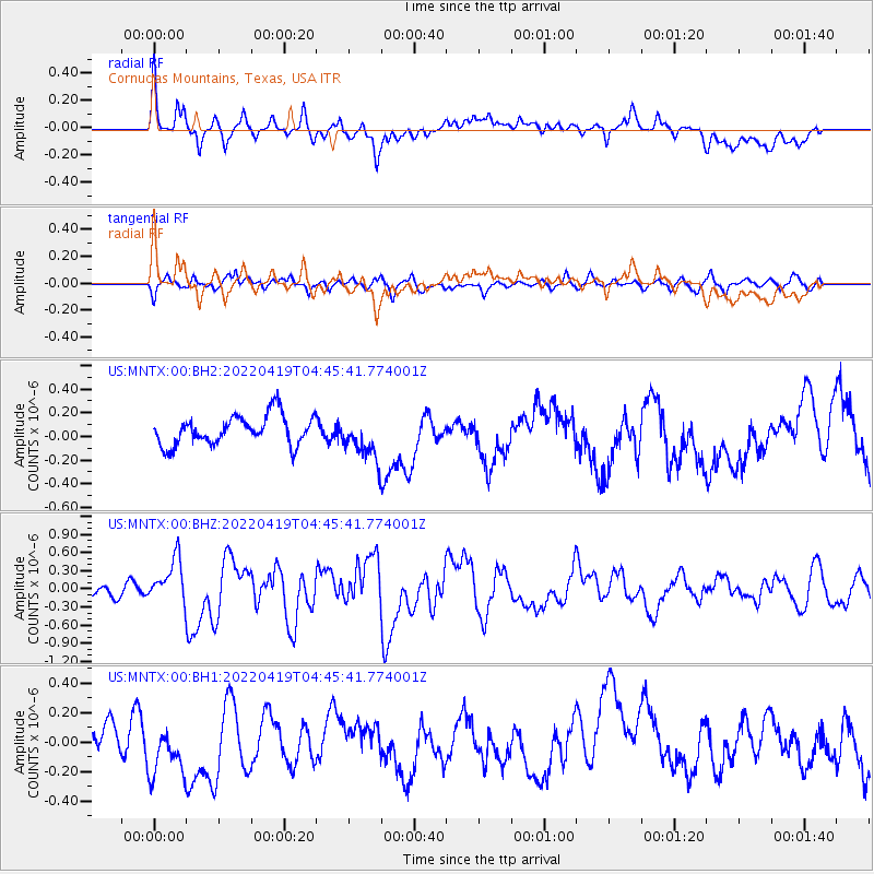
MNTX Cornudas Mountains, Texas, USA - Earthquake Result Viewer
*The percent match for this event was below the threshold and hence no stack was calculated.
| Earthquake location: |
Tonga Islands |
| Earthquake latitude/longitude: |
-21.5/-173.9 |
| Earthquake time(UTC): |
2022/04/19 (109) 04:33:41 GMT |
| Earthquake Depth: |
10 km |
| Earthquake Magnitude: |
6.0 mww |
| Earthquake Catalog/Contributor: |
NEIC PDE/us |
|
| Network: |
US United States National Seismic Network |
| Station: |
MNTX Cornudas Mountains, Texas, USA |
| Lat/Lon: |
31.70 N/105.38 W |
| Elevation: |
405 m |
|
| Distance: |
84.2 deg |
| Az: |
52.873 deg |
| Baz: |
240.616 deg |
| Ray Param: |
$rayparam |
*The percent match for this event was below the threshold and hence was not used in the summary stack. |
|
| Radial Match: |
63.188755 % |
| Radial Bump: |
400 |
| Transverse Match: |
60.913273 % |
| Transverse Bump: |
400 |
| SOD ConfigId: |
27527651 |
| Insert Time: |
2022-05-03 05:03:05.342 +0000 |
| GWidth: |
2.5 |
| Max Bumps: |
400 |
| Tol: |
0.001 |
|
Signal To Noise
| Channel | StoN | STA | LTA |
| US:MNTX:00:BHZ:20220419T04:45:41.774001Z | 5.076288 | 3.6323786E-7 | 7.15558E-8 |
| US:MNTX:00:BH1:20220419T04:45:41.774001Z | 2.2713804 | 2.1116591E-7 | 9.2968094E-8 |
| US:MNTX:00:BH2:20220419T04:45:41.774001Z | 1.5045427 | 1.8576169E-7 | 1.234672E-7 |
| Arrivals |
| Ps | |
| PpPs | |
| PsPs/PpSs | |


