You are here: Home > Network List > UU - University of Utah Regional Network Stations List
> Station FORU South Mineral Mountains, UT, USA > Earthquake Result Viewer
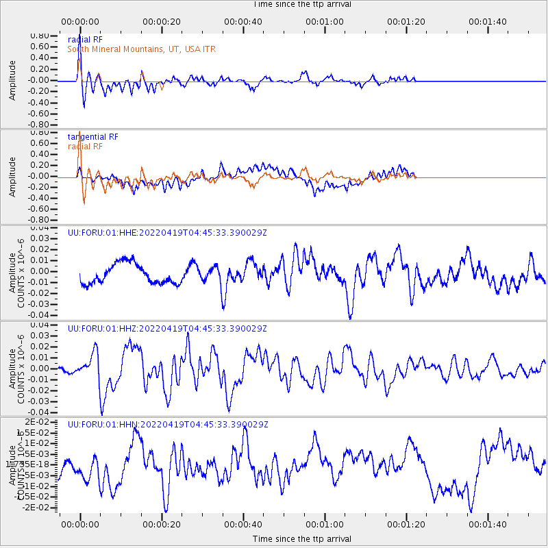
FORU South Mineral Mountains, UT, USA - Earthquake Result Viewer
*The percent match for this event was below the threshold and hence no stack was calculated.
| Earthquake location: |
Tonga Islands |
| Earthquake latitude/longitude: |
-21.5/-173.9 |
| Earthquake time(UTC): |
2022/04/19 (109) 04:33:41 GMT |
| Earthquake Depth: |
10 km |
| Earthquake Magnitude: |
6.0 mww |
| Earthquake Catalog/Contributor: |
NEIC PDE/us |
|
| Network: |
UU University of Utah Regional Network |
| Station: |
FORU South Mineral Mountains, UT, USA |
| Lat/Lon: |
38.46 N/112.86 W |
| Elevation: |
1840 m |
|
| Distance: |
82.6 deg |
| Az: |
43.85 deg |
| Baz: |
235.288 deg |
| Ray Param: |
$rayparam |
*The percent match for this event was below the threshold and hence was not used in the summary stack. |
|
| Radial Match: |
67.92134 % |
| Radial Bump: |
375 |
| Transverse Match: |
64.07395 % |
| Transverse Bump: |
400 |
| SOD ConfigId: |
27527651 |
| Insert Time: |
2022-05-03 05:03:26.653 +0000 |
| GWidth: |
2.5 |
| Max Bumps: |
400 |
| Tol: |
0.001 |
|
Signal To Noise
| Channel | StoN | STA | LTA |
| UU:FORU:01:HHZ:20220419T04:45:33.390029Z | 4.733933 | 1.1532814E-8 | 2.4362012E-9 |
| UU:FORU:01:HHN:20220419T04:45:33.390029Z | 0.7554586 | 5.8849765E-9 | 7.789939E-9 |
| UU:FORU:01:HHE:20220419T04:45:33.390029Z | 0.7712532 | 6.825729E-9 | 8.850179E-9 |
| Arrivals |
| Ps | |
| PpPs | |
| PsPs/PpSs | |


