You are here: Home > Network List > WY - Yellowstone Wyoming Seismic Network Stations List
> Station YMR Madison River, YNP, WY, USA > Earthquake Result Viewer
YMR Madison River, YNP, WY, USA - Earthquake Result Viewer
| Earthquake location: |
Alaska Peninsula |
| Earthquake latitude/longitude: |
54.4/-160.8 |
| Earthquake time(UTC): |
2018/07/19 (200) 14:16:27 GMT |
| Earthquake Depth: |
22 km |
| Earthquake Magnitude: |
5.8 Mww |
| Earthquake Catalog/Contributor: |
NEIC PDE/us |
|
| Network: |
WY Yellowstone Wyoming Seismic Network |
| Station: |
YMR Madison River, YNP, WY, USA |
| Lat/Lon: |
44.67 N/110.96 W |
| Elevation: |
2149 m |
|
| Distance: |
33.1 deg |
| Az: |
86.27 deg |
| Baz: |
305.239 deg |
| Ray Param: |
0.078328446 |
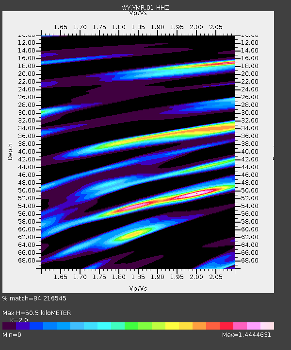
| Estimated Moho Depth: |
50.5 km |
| Estimated Crust Vp/Vs: |
2.00 |
| Assumed Crust Vp: |
6.35 km/s |
| Estimated Crust Vs: |
3.175 km/s |
| Estimated Crust Poisson's Ratio: |
0.33 |
|
| Radial Match: |
84.216545 % |
| Radial Bump: |
400 |
| Transverse Match: |
77.643295 % |
| Transverse Bump: |
400 |
| SOD ConfigId: |
2778632 |
| Insert Time: |
2018-08-02 14:29:51.183 +0000 |
| GWidth: |
2.5 |
| Max Bumps: |
400 |
| Tol: |
0.001 |
|

Signal To Noise
| Channel | StoN | STA | LTA |
| WY:YMR:01:HHZ:20180719T14:22:31.077994Z | 1.7855769 | 5.3611258E-9 | 3.0024614E-9 |
| WY:YMR:01:HHN:20180719T14:22:31.077994Z | 1.438824 | 6.540299E-9 | 4.545586E-9 |
| WY:YMR:01:HHE:20180719T14:22:31.077994Z | 1.009436 | 5.4446083E-9 | 5.3937135E-9 |
| Arrivals |
| Ps | 8.5 SECOND |
| PpPs | 22 SECOND |
| PsPs/PpSs | 31 SECOND |


