You are here: Home > Network List > AZ - ANZA Regional Network Stations List
> Station SMER AZ.SMER > Earthquake Result Viewer
SMER AZ.SMER - Earthquake Result Viewer
*The percent match for this event was below the threshold and hence no stack was calculated.
| Earthquake location: |
Southeast Of Loyalty Islands |
| Earthquake latitude/longitude: |
-22.8/170.9 |
| Earthquake time(UTC): |
2022/04/20 (110) 05:13:07 GMT |
| Earthquake Depth: |
10 km |
| Earthquake Magnitude: |
5.7 Mww |
| Earthquake Catalog/Contributor: |
NEIC PDE/us |
|
| Network: |
AZ ANZA Regional Network |
| Station: |
SMER AZ.SMER |
| Lat/Lon: |
33.46 N/117.17 W |
| Elevation: |
355 m |
|
| Distance: |
88.5 deg |
| Az: |
52.674 deg |
| Baz: |
241.342 deg |
| Ray Param: |
$rayparam |
*The percent match for this event was below the threshold and hence was not used in the summary stack. |
|
| Radial Match: |
41.24604 % |
| Radial Bump: |
400 |
| Transverse Match: |
39.155956 % |
| Transverse Bump: |
400 |
| SOD ConfigId: |
27527651 |
| Insert Time: |
2022-05-04 05:18:15.118 +0000 |
| GWidth: |
2.5 |
| Max Bumps: |
400 |
| Tol: |
0.001 |
|
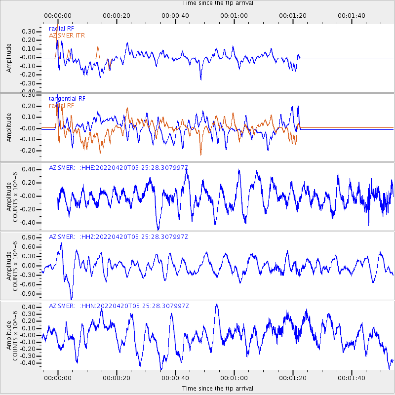
Signal To Noise
| Channel | StoN | STA | LTA |
| AZ:SMER: :HHZ:20220420T05:25:28.307997Z | 3.2897463 | 5.2037825E-7 | 1.5818188E-7 |
| AZ:SMER: :HHN:20220420T05:25:28.307997Z | 0.7908865 | 1.3014349E-7 | 1.6455394E-7 |
| AZ:SMER: :HHE:20220420T05:25:28.307997Z | 2.6990159 | 2.4758353E-7 | 9.173104E-8 |
| Arrivals |
| Ps | |
| PpPs | |
| PsPs/PpSs | |


