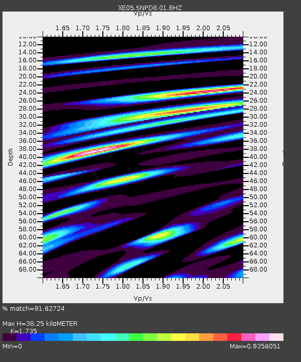
SNPD8 SNPD8 - Earthquake Result Viewer

Earthquake location: Kuril Islands
Earthquake latitude/longitude: 46.4/153.2
Earthquake time(UTC): 2006/09/30 (273) 17:50:23 GMT
Earthquake Depth: 11 km
Earthquake Magnitude: 6.1 MB, 6.5 MS, 6.6 MW, 6.6 MW
Earthquake Catalog/Contributor: WHDF/NEIC
Network: XE Sierra Nevada EarthScope Project- EarthScope Flex Array
Station: SNPD8 SNPD8
Lat/Lon: 39.65 N/120.22 W
Elevation: 1546 m
Distance: 60.7 deg
Az: 62.145 deg
Baz: 307.513 deg
Ray Param: 0.061385095
Estimated Moho Depth: 38.25 km
Estimated Crust Vp/Vs: 1.74
Assumed Crust Vp: 6.597 km/s
Estimated Crust Vs: 3.803 km/s
Estimated Crust Poisson's Ratio: 0.25
Radial Match: 91.62724 %
Radial Bump: 400
Transverse Match: 79.93704 %
Transverse Bump: 400
SOD ConfigId: 268666
Insert Time: 2010-03-09 18:53:08.072 +0000
GWidth: 2.5
Max Bumps: 400
Tol: 0.001

Signal To Noise

ChannelStoNSTALTA
XE:SNPD8:01:BHZ:20060930T18:00:02.940015Z8.099315.951398E-77.34803E-8
XE:SNPD8:01:BHN:20060930T18:00:02.940015Z1.43813481.800028E-71.2516406E-7
XE:SNPD8:01:BHE:20060930T18:00:02.940015Z1.87034542.2765538E-71.2171837E-7
Arrivals
Ps4.5 SECOND
PpPs15 SECOND
PsPs/PpSs20 SECOND