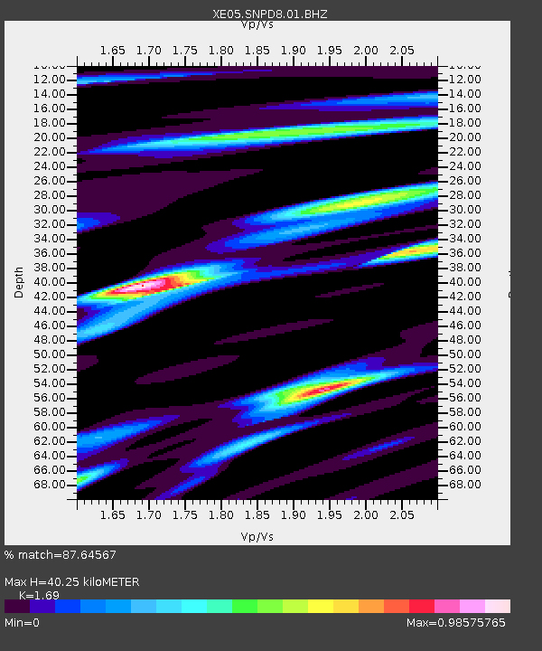
SNPD8 SNPD8 - Earthquake Result Viewer

Earthquake location: Near Coast Of Peru
Earthquake latitude/longitude: -13.5/-76.7
Earthquake time(UTC): 2006/10/20 (293) 10:48:56 GMT
Earthquake Depth: 23 km
Earthquake Magnitude: 5.9 MB, 6.6 MS, 6.7 MW, 6.6 MW
Earthquake Catalog/Contributor: WHDF/NEIC
Network: XE Sierra Nevada EarthScope Project- EarthScope Flex Array
Station: SNPD8 SNPD8
Lat/Lon: 39.65 N/120.22 W
Elevation: 1546 m
Distance: 66.6 deg
Az: 324.573 deg
Baz: 133.075 deg
Ray Param: 0.057493232
Estimated Moho Depth: 40.25 km
Estimated Crust Vp/Vs: 1.69
Assumed Crust Vp: 6.597 km/s
Estimated Crust Vs: 3.904 km/s
Estimated Crust Poisson's Ratio: 0.23
Radial Match: 87.64567 %
Radial Bump: 400
Transverse Match: 89.85809 %
Transverse Bump: 400
SOD ConfigId: 268666
Insert Time: 2010-03-09 18:53:14.820 +0000
GWidth: 2.5
Max Bumps: 400
Tol: 0.001

Signal To Noise

ChannelStoNSTALTA
XE:SNPD8:01:BHZ:20061020T10:59:13.165029Z11.235179.222861E-78.2089194E-8
XE:SNPD8:01:BHN:20061020T10:59:13.165029Z1.1491913.0380323E-72.6436268E-7
XE:SNPD8:01:BHE:20061020T10:59:13.165029Z0.84540022.9980737E-73.5463364E-7
Arrivals
Ps4.4 SECOND
PpPs16 SECOND
PsPs/PpSs20 SECOND