You are here: Home > Network List > IW - Intermountain West Stations List
> Station MOOW Moose Ponds, Wyoming, USA > Earthquake Result Viewer
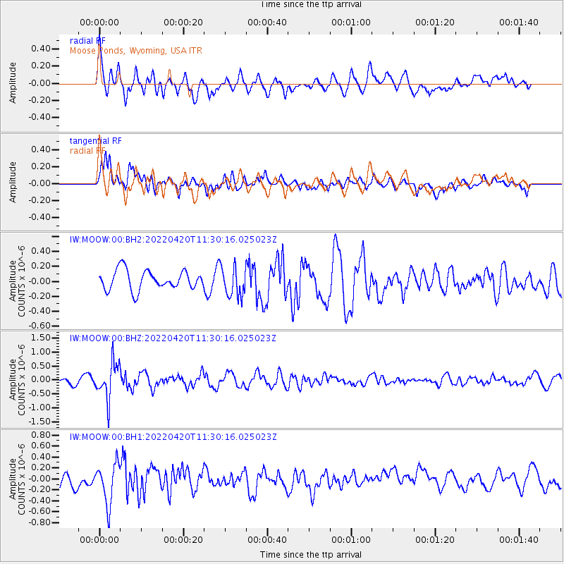
MOOW Moose Ponds, Wyoming, USA - Earthquake Result Viewer
*The percent match for this event was below the threshold and hence no stack was calculated.
| Earthquake location: |
Northern Chile |
| Earthquake latitude/longitude: |
-22.9/-68.2 |
| Earthquake time(UTC): |
2022/04/20 (110) 11:19:04 GMT |
| Earthquake Depth: |
97 km |
| Earthquake Magnitude: |
5.7 mww |
| Earthquake Catalog/Contributor: |
NEIC PDE/us |
|
| Network: |
IW Intermountain West |
| Station: |
MOOW Moose Ponds, Wyoming, USA |
| Lat/Lon: |
43.75 N/110.74 W |
| Elevation: |
2128 m |
|
| Distance: |
77.0 deg |
| Az: |
329.809 deg |
| Baz: |
140.231 deg |
| Ray Param: |
$rayparam |
*The percent match for this event was below the threshold and hence was not used in the summary stack. |
|
| Radial Match: |
71.78252 % |
| Radial Bump: |
400 |
| Transverse Match: |
75.62102 % |
| Transverse Bump: |
400 |
| SOD ConfigId: |
27527651 |
| Insert Time: |
2022-05-04 11:33:30.251 +0000 |
| GWidth: |
2.5 |
| Max Bumps: |
400 |
| Tol: |
0.001 |
|
Signal To Noise
| Channel | StoN | STA | LTA |
| IW:MOOW:00:BHZ:20220420T11:30:16.025023Z | 5.242497 | 6.675032E-7 | 1.2732542E-7 |
| IW:MOOW:00:BH1:20220420T11:30:16.025023Z | 2.713025 | 3.7808644E-7 | 1.3935973E-7 |
| IW:MOOW:00:BH2:20220420T11:30:16.025023Z | 1.4890618 | 1.9067996E-7 | 1.2805376E-7 |
| Arrivals |
| Ps | |
| PpPs | |
| PsPs/PpSs | |


