You are here: Home > Network List > SC - New Mexico Tech Seismic Network Stations List
> Station GDL2 Guadalupe Mountains, New Mexico > Earthquake Result Viewer
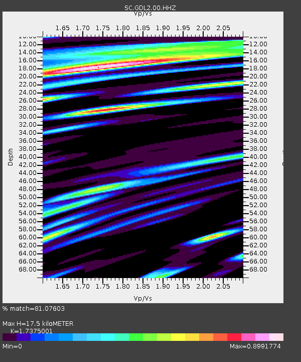
GDL2 Guadalupe Mountains, New Mexico - Earthquake Result Viewer
| Earthquake location: |
Northern Chile |
| Earthquake latitude/longitude: |
-22.9/-68.2 |
| Earthquake time(UTC): |
2022/04/20 (110) 11:19:04 GMT |
| Earthquake Depth: |
97 km |
| Earthquake Magnitude: |
5.7 mww |
| Earthquake Catalog/Contributor: |
NEIC PDE/us |
|
| Network: |
SC New Mexico Tech Seismic Network |
| Station: |
GDL2 Guadalupe Mountains, New Mexico |
| Lat/Lon: |
32.20 N/104.36 W |
| Elevation: |
1211 m |
|
| Distance: |
64.8 deg |
| Az: |
326.445 deg |
| Baz: |
143.056 deg |
| Ray Param: |
0.05842595 |
| Estimated Moho Depth: |
17.5 km |
| Estimated Crust Vp/Vs: |
1.74 |
| Assumed Crust Vp: |
6.232 km/s |
| Estimated Crust Vs: |
3.587 km/s |
| Estimated Crust Poisson's Ratio: |
0.25 |
|
| Radial Match: |
81.07603 % |
| Radial Bump: |
400 |
| Transverse Match: |
72.22803 % |
| Transverse Bump: |
400 |
| SOD ConfigId: |
27527651 |
| Insert Time: |
2022-05-04 11:44:03.299 +0000 |
| GWidth: |
2.5 |
| Max Bumps: |
400 |
| Tol: |
0.001 |
|

Signal To Noise
| Channel | StoN | STA | LTA |
| SC:GDL2:00:HHZ:20220420T11:29:02.635008Z | 30.848017 | 1.9899913E-7 | 6.450954E-9 |
| SC:GDL2:00:HHN:20220420T11:29:02.635008Z | 11.712828 | 5.6129306E-8 | 4.7921223E-9 |
| SC:GDL2:00:HHE:20220420T11:29:02.635008Z | 8.441098 | 4.7397542E-8 | 5.615092E-9 |
| Arrivals |
| Ps | 2.2 SECOND |
| PpPs | 7.4 SECOND |
| PsPs/PpSs | 9.5 SECOND |


