You are here: Home > Network List > IW - Intermountain West Stations List
> Station MOOW Moose Ponds, Wyoming, USA > Earthquake Result Viewer
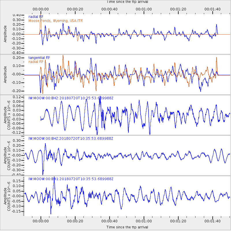
MOOW Moose Ponds, Wyoming, USA - Earthquake Result Viewer
*The percent match for this event was below the threshold and hence no stack was calculated.
| Earthquake location: |
Santiago Del Estero Prov., Arg. |
| Earthquake latitude/longitude: |
-28.1/-63.3 |
| Earthquake time(UTC): |
2018/07/20 (201) 10:24:57 GMT |
| Earthquake Depth: |
588 km |
| Earthquake Magnitude: |
5.6 Mww |
| Earthquake Catalog/Contributor: |
NEIC PDE/us |
|
| Network: |
IW Intermountain West |
| Station: |
MOOW Moose Ponds, Wyoming, USA |
| Lat/Lon: |
43.75 N/110.74 W |
| Elevation: |
2128 m |
|
| Distance: |
83.7 deg |
| Az: |
327.487 deg |
| Baz: |
139.049 deg |
| Ray Param: |
$rayparam |
*The percent match for this event was below the threshold and hence was not used in the summary stack. |
|
| Radial Match: |
49.991764 % |
| Radial Bump: |
400 |
| Transverse Match: |
56.276787 % |
| Transverse Bump: |
400 |
| SOD ConfigId: |
2778632 |
| Insert Time: |
2018-08-03 10:29:26.991 +0000 |
| GWidth: |
2.5 |
| Max Bumps: |
400 |
| Tol: |
0.001 |
|
Signal To Noise
| Channel | StoN | STA | LTA |
| IW:MOOW:00:BHZ:20180720T10:35:53.689988Z | 3.8088102 | 1.5614015E-7 | 4.099447E-8 |
| IW:MOOW:00:BH1:20180720T10:35:53.689988Z | 1.2859182 | 3.967823E-8 | 3.085595E-8 |
| IW:MOOW:00:BH2:20180720T10:35:53.689988Z | 1.4079126 | 7.0886344E-8 | 5.0348536E-8 |
| Arrivals |
| Ps | |
| PpPs | |
| PsPs/PpSs | |


