You are here: Home > Network List > UW - Pacific Northwest Regional Seismic Network Stations List
> Station UMAT Pilot Rock, OR, USA > Earthquake Result Viewer
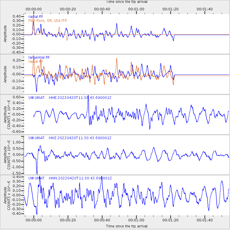
UMAT Pilot Rock, OR, USA - Earthquake Result Viewer
*The percent match for this event was below the threshold and hence no stack was calculated.
| Earthquake location: |
Northern Chile |
| Earthquake latitude/longitude: |
-22.9/-68.2 |
| Earthquake time(UTC): |
2022/04/20 (110) 11:19:04 GMT |
| Earthquake Depth: |
97 km |
| Earthquake Magnitude: |
5.7 mww |
| Earthquake Catalog/Contributor: |
NEIC PDE/us |
|
| Network: |
UW Pacific Northwest Regional Seismic Network |
| Station: |
UMAT Pilot Rock, OR, USA |
| Lat/Lon: |
45.29 N/118.96 W |
| Elevation: |
1318 m |
|
| Distance: |
82.1 deg |
| Az: |
326.503 deg |
| Baz: |
133.885 deg |
| Ray Param: |
$rayparam |
*The percent match for this event was below the threshold and hence was not used in the summary stack. |
|
| Radial Match: |
42.56197 % |
| Radial Bump: |
400 |
| Transverse Match: |
57.27269 % |
| Transverse Bump: |
400 |
| SOD ConfigId: |
27527651 |
| Insert Time: |
2022-05-04 11:51:16.946 +0000 |
| GWidth: |
2.5 |
| Max Bumps: |
400 |
| Tol: |
0.001 |
|
Signal To Noise
| Channel | StoN | STA | LTA |
| UW:UMAT: :HHZ:20220420T11:30:43.690001Z | 3.4715385 | 5.717549E-7 | 1.6469784E-7 |
| UW:UMAT: :HHN:20220420T11:30:43.690001Z | 1.6517779 | 2.3630365E-7 | 1.4306019E-7 |
| UW:UMAT: :HHE:20220420T11:30:43.690001Z | 2.066614 | 2.4636694E-7 | 1.1921286E-7 |
| Arrivals |
| Ps | |
| PpPs | |
| PsPs/PpSs | |


