You are here: Home > Network List > CN - Canadian National Seismograph Network Stations List
> Station INK INUVIK, NT > Earthquake Result Viewer
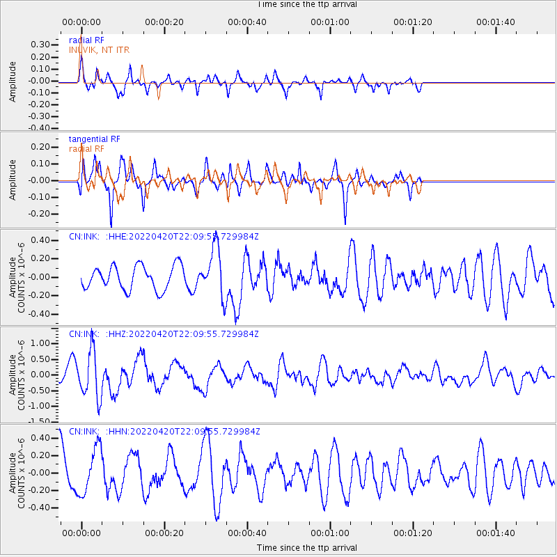
INK INUVIK, NT - Earthquake Result Viewer
*The percent match for this event was below the threshold and hence no stack was calculated.
| Earthquake location: |
Mindanao, Philippines |
| Earthquake latitude/longitude: |
7.0/126.9 |
| Earthquake time(UTC): |
2022/04/20 (110) 21:57:46 GMT |
| Earthquake Depth: |
51 km |
| Earthquake Magnitude: |
6.0 mww |
| Earthquake Catalog/Contributor: |
NEIC PDE/us |
|
| Network: |
CN Canadian National Seismograph Network |
| Station: |
INK INUVIK, NT |
| Lat/Lon: |
68.31 N/133.53 W |
| Elevation: |
44 m |
|
| Distance: |
87.1 deg |
| Az: |
21.539 deg |
| Baz: |
281.404 deg |
| Ray Param: |
$rayparam |
*The percent match for this event was below the threshold and hence was not used in the summary stack. |
|
| Radial Match: |
71.01899 % |
| Radial Bump: |
328 |
| Transverse Match: |
64.37643 % |
| Transverse Bump: |
297 |
| SOD ConfigId: |
27527651 |
| Insert Time: |
2022-05-04 22:06:37.911 +0000 |
| GWidth: |
2.5 |
| Max Bumps: |
400 |
| Tol: |
0.001 |
|
Signal To Noise
| Channel | StoN | STA | LTA |
| CN:INK: :HHZ:20220420T22:09:55.729984Z | 3.268732 | 7.494423E-7 | 2.2927614E-7 |
| CN:INK: :HHN:20220420T22:09:55.729984Z | 1.1877025 | 2.672946E-7 | 2.2505182E-7 |
| CN:INK: :HHE:20220420T22:09:55.729984Z | 2.1567132 | 2.732783E-7 | 1.2671053E-7 |
| Arrivals |
| Ps | |
| PpPs | |
| PsPs/PpSs | |


