You are here: Home > Network List > IU - Global Seismograph Network (GSN - IRIS/USGS) Stations List
> Station MAKZ Makanchi, Kazakhstan > Earthquake Result Viewer
MAKZ Makanchi, Kazakhstan - Earthquake Result Viewer
| Earthquake location: |
Mindanao, Philippines |
| Earthquake latitude/longitude: |
7.0/126.9 |
| Earthquake time(UTC): |
2022/04/20 (110) 21:57:46 GMT |
| Earthquake Depth: |
51 km |
| Earthquake Magnitude: |
6.0 mww |
| Earthquake Catalog/Contributor: |
NEIC PDE/us |
|
| Network: |
IU Global Seismograph Network (GSN - IRIS/USGS) |
| Station: |
MAKZ Makanchi, Kazakhstan |
| Lat/Lon: |
46.81 N/81.98 E |
| Elevation: |
600 m |
|
| Distance: |
55.2 deg |
| Az: |
323.779 deg |
| Baz: |
121.355 deg |
| Ray Param: |
0.06479931 |
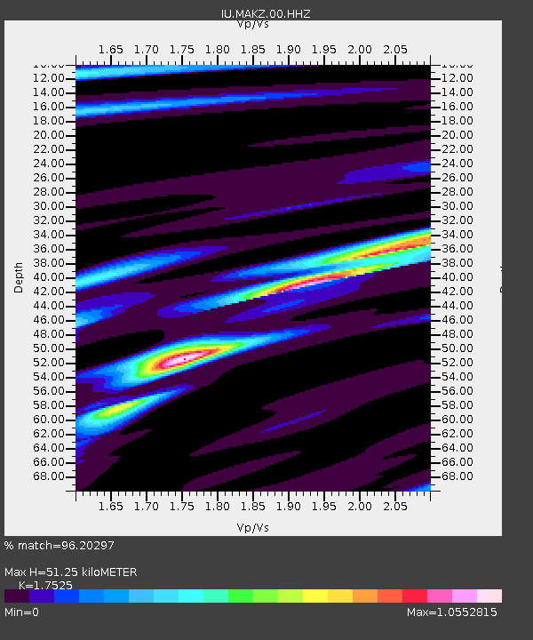
| Estimated Moho Depth: |
51.25 km |
| Estimated Crust Vp/Vs: |
1.75 |
| Assumed Crust Vp: |
6.571 km/s |
| Estimated Crust Vs: |
3.749 km/s |
| Estimated Crust Poisson's Ratio: |
0.26 |
|
| Radial Match: |
96.20297 % |
| Radial Bump: |
286 |
| Transverse Match: |
85.8886 % |
| Transverse Bump: |
400 |
| SOD ConfigId: |
27527651 |
| Insert Time: |
2022-05-04 22:09:08.193 +0000 |
| GWidth: |
2.5 |
| Max Bumps: |
400 |
| Tol: |
0.001 |
|
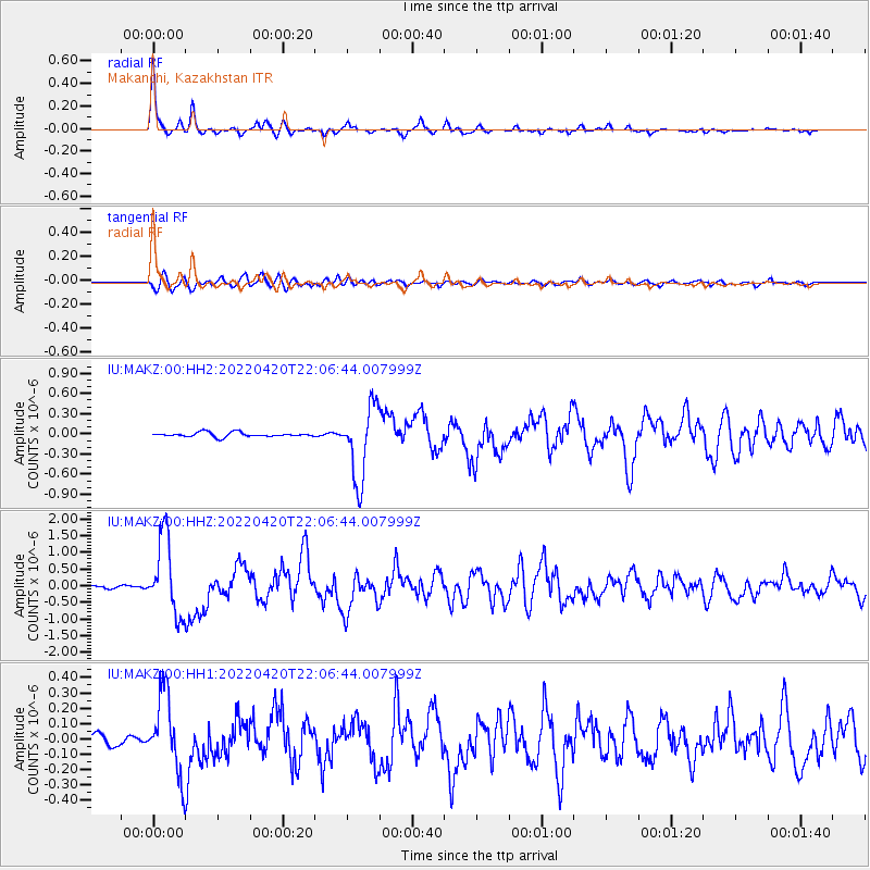
Signal To Noise
| Channel | StoN | STA | LTA |
| IU:MAKZ:00:HHZ:20220420T22:06:44.007999Z | 27.79984 | 1.1578239E-6 | 4.1648583E-8 |
| IU:MAKZ:00:HH1:20220420T22:06:44.007999Z | 9.887033 | 2.5913434E-7 | 2.6209516E-8 |
| IU:MAKZ:00:HH2:20220420T22:06:44.007999Z | 16.952976 | 5.452607E-7 | 3.2163125E-8 |
| Arrivals |
| Ps | 6.2 SECOND |
| PpPs | 20 SECOND |
| PsPs/PpSs | 27 SECOND |


