You are here: Home > Network List > MM - Myanmar National Seismic Network Stations List
> Station TGI Taung Gyi, Myanmar > Earthquake Result Viewer
TGI Taung Gyi, Myanmar - Earthquake Result Viewer
| Earthquake location: |
Mindanao, Philippines |
| Earthquake latitude/longitude: |
7.0/126.9 |
| Earthquake time(UTC): |
2022/04/20 (110) 21:57:46 GMT |
| Earthquake Depth: |
51 km |
| Earthquake Magnitude: |
6.0 mww |
| Earthquake Catalog/Contributor: |
NEIC PDE/us |
|
| Network: |
MM Myanmar National Seismic Network |
| Station: |
TGI Taung Gyi, Myanmar |
| Lat/Lon: |
20.77 N/97.03 E |
| Elevation: |
1458 m |
|
| Distance: |
32.0 deg |
| Az: |
298.368 deg |
| Baz: |
111.03 deg |
| Ray Param: |
0.078735895 |
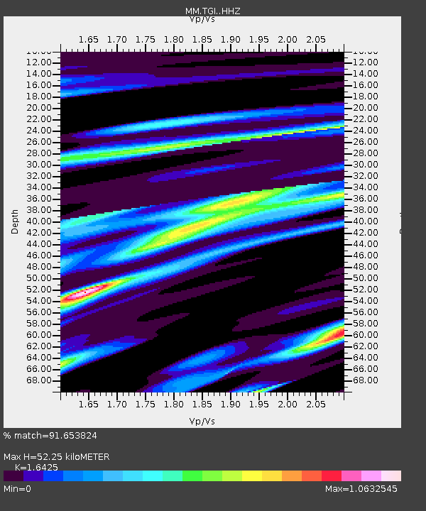
| Estimated Moho Depth: |
52.25 km |
| Estimated Crust Vp/Vs: |
1.64 |
| Assumed Crust Vp: |
6.316 km/s |
| Estimated Crust Vs: |
3.845 km/s |
| Estimated Crust Poisson's Ratio: |
0.21 |
|
| Radial Match: |
91.653824 % |
| Radial Bump: |
291 |
| Transverse Match: |
63.796513 % |
| Transverse Bump: |
400 |
| SOD ConfigId: |
27527651 |
| Insert Time: |
2022-05-04 22:10:14.207 +0000 |
| GWidth: |
2.5 |
| Max Bumps: |
400 |
| Tol: |
0.001 |
|

Signal To Noise
| Channel | StoN | STA | LTA |
| MM:TGI: :HHZ:20220420T22:03:38.179996Z | 21.924677 | 1.0844974E-6 | 4.9464695E-8 |
| MM:TGI: :HHN:20220420T22:03:38.179996Z | 7.288896 | 2.74173E-7 | 3.7615163E-8 |
| MM:TGI: :HHE:20220420T22:03:38.179996Z | 25.31785 | 6.666282E-7 | 2.6330364E-8 |
| Arrivals |
| Ps | 5.8 SECOND |
| PpPs | 20 SECOND |
| PsPs/PpSs | 26 SECOND |


